
Spenden
Rüste dich für dein nächstes Abenteuer:
Als Amazon-Partner verdient diese Seite an qualifizierten Käufen, ohne dass Ihnen zusätzliche Kosten entstehen.
Topografische Karte Pocono Township
Klicken Sie auf die Karte, um die Höhe anzuzeigen.
Spenden
Rüste dich für dein nächstes Abenteuer:
Als Amazon-Partner verdient diese Seite an qualifizierten Käufen, ohne dass Ihnen zusätzliche Kosten entstehen.
Über diese Karte
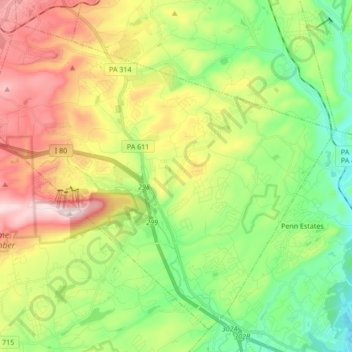
Name: Topografische Karte Pocono Township, Höhe, Relief.
Ort: Pocono Township, Monroe County, Pennsylvania, United States (40.99978 -75.39357 41.11146 -75.22348)
Durchschnittliche Höhe: 336 m
Minimale Höhe: 143 m
Maximale Höhe: 638 m
Spenden
Rüste dich für dein nächstes Abenteuer:
Als Amazon-Partner verdient diese Seite an qualifizierten Käufen, ohne dass Ihnen zusätzliche Kosten entstehen.
Andere topografische Karten
Klicken Sie auf eine Karte, um ihre Topografie, ihre Höhe und ihr Relief anzuzeigen.
Mount Nebo Park
United States > Pennsylvania > Monroe County > East Stroudsburg > Twin Falls
Durchschnittliche Höhe: 185 m
Tobyhanna
United States > Pennsylvania > Monroe County > Coolbaugh Township
Durchschnittliche Höhe: 590 m
Skytop
United States > Pennsylvania > Monroe County > Barrett Township
Skytop is an unincorporated community in Barrett Township, Monroe County, Pennsylvania, United States. Located north of Mountainhome, it is accessible by local roads off Route 390. Its elevation is 1,562 feet (476 m), and it is located at 41°13′40″N 75°14′18″W / 41.22778°N 75.23833°W /…
Durchschnittliche Höhe: 469 m
Blue Mountain
United States > Pennsylvania > Monroe County > Eldred Township
The ridge of Blue Mountain runs for 150 miles (240 km) through Pennsylvania, reaching an elevation of 2,270 feet (690 m) above sea level just north of the Pennsylvania Turnpike, near the borough of Newburg. Most of the ridgecrest, however, only reaches between 1,400 and 1,700 feet (430 and 520 m) in elevation.…
Durchschnittliche Höhe: 242 m
Spenden
Rüste dich für dein nächstes Abenteuer:
Als Amazon-Partner verdient diese Seite an qualifizierten Käufen, ohne dass Ihnen zusätzliche Kosten entstehen.
Pocono Lake
United States > Pennsylvania > Monroe County > Tobyhanna Township
Durchschnittliche Höhe: 543 m
Tannersville
United States > Pennsylvania > Monroe County > Pocono Township
Durchschnittliche Höhe: 316 m
Kunkletown
United States > Pennsylvania > Monroe County > Eldred Township
Kunkletown is an unincorporated community in Eldred Township, Monroe County, Pennsylvania, United States. It is located at an elevation of 531 feet. It is at ZIP Code 18058.
Durchschnittliche Höhe: 224 m
Blakeslee
United States > Pennsylvania > Monroe County > Tobyhanna Township
Durchschnittliche Höhe: 504 m
Spenden
Rüste dich für dein nächstes Abenteuer:
Als Amazon-Partner verdient diese Seite an qualifizierten Käufen, ohne dass Ihnen zusätzliche Kosten entstehen.
Long Pond
United States > Pennsylvania > Monroe County > Tunkhannock Township
Long Pond is named after the unique wetland topography formed by the Tunkhannock Creek. Within the Long Pond community, public access lands are owned and protected by The Bethlehem Authority, Nature Conservancy, Wildlands Conservancy County of Monroe Open Space Program, , PA Game Commission and PA Department…
Durchschnittliche Höhe: 571 m
Henryville
United States > Pennsylvania > Monroe County > Paradise Township
Durchschnittliche Höhe: 271 m
Canadensis
United States > Pennsylvania > Monroe County > Barrett Township
Durchschnittliche Höhe: 368 m
Spenden
Rüste dich für dein nächstes Abenteuer:
Als Amazon-Partner verdient diese Seite an qualifizierten Käufen, ohne dass Ihnen zusätzliche Kosten entstehen.
Gilbert
United States > Pennsylvania > Monroe County > Chestnuthill Township
Durchschnittliche Höhe: 242 m
Bartonsville
United States > Pennsylvania > Monroe County > Pocono Township
Durchschnittliche Höhe: 265 m
Swiftwater
United States > Pennsylvania > Monroe County > Pocono Township
Durchschnittliche Höhe: 387 m
Marshalls Creek
United States > Pennsylvania > Monroe County > Smithfield Township
Durchschnittliche Höhe: 186 m
Spenden
Rüste dich für dein nächstes Abenteuer:
Als Amazon-Partner verdient diese Seite an qualifizierten Käufen, ohne dass Ihnen zusätzliche Kosten entstehen.
Pocono Summit
United States > Pennsylvania > Monroe County > Tobyhanna Township
Durchschnittliche Höhe: 547 m
Shawnee on Delaware
United States > Pennsylvania > Monroe County > Smithfield Township
Durchschnittliche Höhe: 188 m
Tobyhanna
United States > Pennsylvania > Monroe County > Coolbaugh Township
Durchschnittliche Höhe: 590 m
Spenden
Rüste dich für dein nächstes Abenteuer:
Als Amazon-Partner verdient diese Seite an qualifizierten Käufen, ohne dass Ihnen zusätzliche Kosten entstehen.
Bartonsville
United States > Pennsylvania > Monroe County > Pocono Township
Durchschnittliche Höhe: 265 m
Long Pond
United States > Pennsylvania > Monroe County > Tunkhannock Township
Long Pond is named after the wetland topography formed by Tunkhannock Creek. Within the Long Pond community are public access lands, containing many species of plants and animals. Long Pond has been called "the most unique inland freshwater wetland in the state".
Durchschnittliche Höhe: 571 m
Camelback Mountain
United States > Pennsylvania > Monroe County > Jackson Township
Durchschnittliche Höhe: 458 m
Swiftwater
United States > Pennsylvania > Monroe County > Pocono Township
Durchschnittliche Höhe: 387 m
Spenden
Rüste dich für dein nächstes Abenteuer:
Als Amazon-Partner verdient diese Seite an qualifizierten Käufen, ohne dass Ihnen zusätzliche Kosten entstehen.
Gilbert
United States > Pennsylvania > Monroe County > Chestnuthill Township
Durchschnittliche Höhe: 242 m
Pocono Lake
United States > Pennsylvania > Monroe County > Tobyhanna Township
Durchschnittliche Höhe: 543 m
Pocono Manor
United States > Pennsylvania > Monroe County > Pocono Township
Durchschnittliche Höhe: 486 m
Long Pond
United States > Pennsylvania > Monroe County > Tunkhannock Township
Long Pond is named after the wetland topography formed by Tunkhannock Creek. Within the Long Pond community are public access lands, containing many species of plants and animals. Long Pond has been called "the most unique inland freshwater wetland in the state".
Durchschnittliche Höhe: 571 m
Spenden
Rüste dich für dein nächstes Abenteuer:
Als Amazon-Partner verdient diese Seite an qualifizierten Käufen, ohne dass Ihnen zusätzliche Kosten entstehen.
Blakeslee
United States > Pennsylvania > Monroe County > Tobyhanna Township
Durchschnittliche Höhe: 504 m