
Topografische Karte Sioux County
Interaktive Karte
Klicken Sie auf die Karte, um die Höhe anzuzeigen.
Über diese Karte
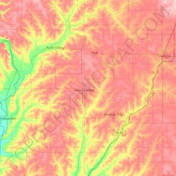
Name: Topografische Karte Sioux County, Höhe, Relief.
Ort: Sioux County, Iowa, United States (42.90908 -96.57149 43.26003 -95.85839)
Durchschnittliche Höhe: 418 m
Minimale Höhe: 351 m
Maximale Höhe: 466 m
Andere topografische Karten
Klicken Sie auf eine Karte, um ihre Topografie, ihre Höhe und ihr Relief anzuzeigen.
Chatsworth
United States > Iowa > Sioux County > Chatsworth > Chatsworth
Chatsworth, Sioux County, Iowa, 51011, United States
Durchschnittliche Höhe: 359 m
Chatsworth
United States > Iowa > Sioux County
Chatsworth, Sioux County, Iowa, 51011, United States
Durchschnittliche Höhe: 357 m
Hawarden
United States > Iowa > Sioux County
Hawarden, Sioux County, Iowa, United States
Durchschnittliche Höhe: 365 m