
Spenden
Rüste dich für dein nächstes Abenteuer:
Als Amazon-Partner verdient diese Seite an qualifizierten Käufen, ohne dass Ihnen zusätzliche Kosten entstehen.
Topografische Karte Gulf Hills
Klicken Sie auf die Karte, um die Höhe anzuzeigen.
Spenden
Rüste dich für dein nächstes Abenteuer:
Als Amazon-Partner verdient diese Seite an qualifizierten Käufen, ohne dass Ihnen zusätzliche Kosten entstehen.
Gulf Hills
The terrain in the Bayou Porteaux region is relatively high considering its proximity to the Gulf of Mexico. Elevations range from sea level to 25 feet (7.6 m) above sea level. The area of interest lies south of the Big Ridge escarpment, on the western terminus of an east-west striking coastal ridge, which is sub-parallel to the Big Ridge. Here small bayous and streams have dissected the topography with steep ravines to create a "hilly" terrain. Reconnaissance, surface and geologic investigations indicate that alluvial-fluvial deposits of the Late Pleistocene Prairie Formation are exposed in the higher areas of the Bayou Porteaux-Gulf Hills section.
Spenden
Rüste dich für dein nächstes Abenteuer:
Als Amazon-Partner verdient diese Seite an qualifizierten Käufen, ohne dass Ihnen zusätzliche Kosten entstehen.
Über diese Karte
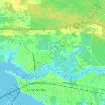
Name: Topografische Karte Gulf Hills, Höhe, Relief.
Ort: Gulf Hills, Jackson County, Mississippi, United States (30.41860 -88.85797 30.45630 -88.77216)
Durchschnittliche Höhe: 8 m
Minimale Höhe: -2 m
Maximale Höhe: 18 m
Spenden
Rüste dich für dein nächstes Abenteuer:
Als Amazon-Partner verdient diese Seite an qualifizierten Käufen, ohne dass Ihnen zusätzliche Kosten entstehen.
Andere topografische Karten
Klicken Sie auf eine Karte, um ihre Topografie, ihre Höhe und ihr Relief anzuzeigen.
South Pascagoula
United States > Mississippi > Jackson County > Pascagoula
Durchschnittliche Höhe: 3 m
Spenden
Rüste dich für dein nächstes Abenteuer:
Als Amazon-Partner verdient diese Seite an qualifizierten Käufen, ohne dass Ihnen zusätzliche Kosten entstehen.
Channel Island
United States > Mississippi > Jackson County > Ocean Springs
Durchschnittliche Höhe: 11 m