
Topografische Karte Municipality of Mykonos
Interaktive Karte
Klicken Sie auf die Karte, um die Höhe anzuzeigen.
Über diese Karte
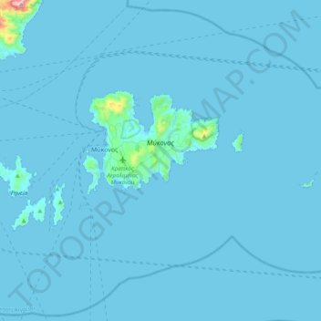
Name: Topografische Karte Municipality of Mykonos, Höhe, Relief.
Durchschnittliche Höhe: 11 m
Minimale Höhe: 0 m
Maximale Höhe: 703 m
Andere topografische Karten
Klicken Sie auf eine Karte, um ihre Topografie, ihre Höhe und ihr Relief anzuzeigen.
Mykonos
Greece > Aegean > Mykonos Regional Unit > Agios Stefanos
Mykonos, Agios Stefanos, Municipality of Mykonos, Mykonos Regional Unit, South Aegean, Aegean, 846 00, Greece
Durchschnittliche Höhe: 38 m
Mykonos
Greece > Aegean > Mykonos Regional Unit
Mykonos, Municipality of Mykonos, Mykonos Regional Unit, South Aegean, Aegean, 846 00, Greece
Durchschnittliche Höhe: 46 m
Delos
Greece > Aegean > Mykonos Regional Unit
Delos, Municipality of Mykonos, Mykonos Regional Unit, South Aegean, Aegean, Greece
Durchschnittliche Höhe: 7 m
Sacred Lake
Greece > Aegean > Mykonos Regional Unit
Sacred Lake, Municipality of Mykonos, Mykonos Regional Unit, South Aegean, Aegean, Greece
Durchschnittliche Höhe: 8 m