
Topografische Karte Seymour
Interaktive Karte
Klicken Sie auf die Karte, um die Höhe anzuzeigen.
Über diese Karte
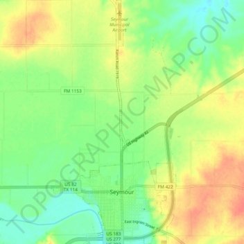
Name: Topografische Karte Seymour, Höhe, Relief.
Ort: Seymour, Baylor County, Texas, 76380, United States (33.57758 -99.28730 33.65528 -99.23953)
Durchschnittliche Höhe: 401 m
Minimale Höhe: 379 m
Maximale Höhe: 426 m
The climate is humid subtropical (Köppen: Cfa) with an extreme temperature deviation, but much of the time, the variation is always more and the warm weather prevails over the cold as the averages and the records show. Its subtropical location and south of the center of a large land mass bring occasional outbreaks even to a latitude and not very high altitude. The climate in this area is characterized by hot, humid summers and generally mild to cool winters, sometimes cold. On August 12, 1936, Seymour witnessed the record highest temperature in Texas (120 °F) (49 °C), a record that was tied by the city of Monahans on June 28, 1994.
Andere topografische Karten
Klicken Sie auf eine Karte, um ihre Topografie, ihre Höhe und ihr Relief anzuzeigen.
Seymour
United States > Texas > Baylor County
Seymour, Baylor County, Texas, 76380, United States
Durchschnittliche Höhe: 401 m