
Topografische Karte Elk Grove
Interaktive Karte
Klicken Sie auf die Karte, um die Höhe anzuzeigen.
Über diese Karte
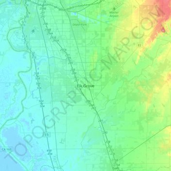
Name: Topografische Karte Elk Grove, Höhe, Relief.
Durchschnittliche Höhe: 17 m
Minimale Höhe: -3 m
Maximale Höhe: 95 m
Andere topografische Karten
Klicken Sie auf eine Karte, um ihre Topografie, ihre Höhe und ihr Relief anzuzeigen.
Brighton
United States > California > Sacramento County > Sacramento
Brighton, Sacramento, Sacramento County, CAL Fire Northern Region, California, 95819, United States
Durchschnittliche Höhe: 14 m
American River
United States > California > Sacramento County > Rancho Cordova
American River, Rancho Cordova, Sacramento County, CAL Fire Northern Region, California, United States
Durchschnittliche Höhe: 44 m
Polk
United States > California > Sacramento County > Sacramento
Polk, Sacramento, Sacramento County, CAL Fire Northern Region, California, 95826, United States
Durchschnittliche Höhe: 13 m
Point Pleasant
United States > California > Sacramento County > Elk Grove
Point Pleasant, Elk Grove, Sacramento County, CAL Fire Northern Region, California, United States
Durchschnittliche Höhe: 4 m
Sacramento
United States > California > Sacramento County
Sacramento, Sacramento County, CAL Fire Northern Region, California, United States
Durchschnittliche Höhe: 10 m
Fair Oaks
United States > California > Sacramento County
Fair Oaks, Sacramento County, CAL Fire Northern Region, California, 95628, United States
Durchschnittliche Höhe: 55 m
Galt
United States > California > Sacramento County > Galt > Galt
Galt, Sacramento County, California, 95632, United States
Durchschnittliche Höhe: 16 m
Vineyard
United States > California > Sacramento County > Elk Grove
Vineyard, Elk Grove, Sacramento County, California, 95829, United States
Durchschnittliche Höhe: 21 m