
Topografische Karte Tripoli
Interaktive Karte
Klicken Sie auf die Karte, um die Höhe anzuzeigen.
Über diese Karte
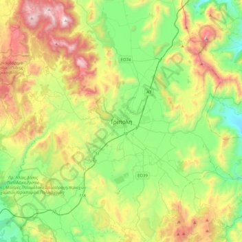
Name: Topografische Karte Tripoli, Höhe, Relief.
Durchschnittliche Höhe: 873 m
Minimale Höhe: 274 m
Maximale Höhe: 1’966 m
The city of Tripolis has a hot-summer Mediterranean climate (Köppen: Csa). Ιt is located in the center of the Peloponnese, at the western border of a large basin (a polje at about 650 m in altitude, a length of ca. 30 km and a width between 12,5 and 2,5 km). The city is today the capital of the regional unit Arcadia (residents, city alone, ca. 30 000, district with hinterland ca. 47500, 2011 Greek census). At its west the city borders the thickly wooded mountain-area “Mainalo”. The Tripoli Basin has gradually been rainwater regulated (mainly after 1945 ) and turned into farmland. In the southwest floods, which appear in the basin occasionally after rainy winters, as in 2003, formed the temporary Lake Taka. This lake was regulated by a new pond, to retain water for irrigation.
Andere topografische Karten
Klicken Sie auf eine Karte, um ihre Topografie, ihre Höhe und ihr Relief anzuzeigen.
Nestani
Greece > Peloponnese, Western Greece and the Ionian > Arcadia Regional Unit > Municipal Unit of Mantineia
Nestani, Municipal Unit of Mantineia, Municipality of Tripoli, Arcadia Regional Unit, Peloponnese Region, Peloponnese, Western Greece and the Ionian, 220 05, Greece
Durchschnittliche Höhe: 827 m
Tower of Nestani
Greece > Peloponnese, Western Greece and the Ionian > Arcadia Regional Unit > Municipal Unit of Mantineia
Tower of Nestani, Corinth - Tripoli - Kalamata, κ. Σάγκα, Community of Nestani, Municipal Unit of Mantineia, Municipality of Tripoli, Arcadia Regional Unit, Peloponnese Region, Peloponnese, Western Greece and the Ionian, 220 05, Greece
Durchschnittliche Höhe: 753 m
Kastri
Greece > Peloponnese, Western Greece and the Ionian > Arcadia Regional Unit
Kastri, Municipality of North Kynouria, Arcadia Regional Unit, Peloponnese Region, Peloponnese, Western Greece and the Ionian, 220 13, Greece
Durchschnittliche Höhe: 944 m
Agios Andreas
Greece > Peloponnese, Western Greece and the Ionian > Arcadia Regional Unit
Agios Andreas, Municipality of North Kynouria, Arcadia Regional Unit, Peloponnese Region, Peloponnese, Western Greece and the Ionian, 220 06, Greece
Durchschnittliche Höhe: 164 m
Akra
Greece > Peloponnese, Western Greece and the Ionian > Arcadia Regional Unit > Municipal Unit of Tegea
Akra, Stadio Community, Municipal Unit of Tegea, Municipality of Tripoli, Arcadia Regional Unit, Peloponnese Region, Peloponnese, Western Greece and the Ionian, 220 12, Greece
Durchschnittliche Höhe: 666 m
Astros Beach
Greece > Peloponnese, Western Greece and the Ionian > Arcadia Regional Unit
Astros Beach, Municipality of North Kynouria, Arcadia Regional Unit, Peloponnese Region, Peloponnese, Western Greece and the Ionian, 220 19, Greece
Durchschnittliche Höhe: 3 m
Lousios
Greece > Peloponnese, Western Greece and the Ionian > Arcadia Regional Unit > Municipal Unit of Gortyna
Lousios, κ. Ατσιχόλου, Municipal Unit of Gortyna, Municipality of Megalopoli, Arcadia Regional Unit, Peloponnese Region, Peloponnese, Western Greece and the Ionian, 220 24, Greece
Durchschnittliche Höhe: 440 m
Megalopoli
Greece > Peloponnese, Western Greece and the Ionian > Arcadia Regional Unit > Municipal Unit of Megalopoli
Megalopoli, Municipal Unit of Megalopoli, Municipality of Megalopoli, Arcadia Regional Unit, Peloponnese Region, Peloponnese, Western Greece and the Ionian, 222 00, Greece
Durchschnittliche Höhe: 434 m
Chirades
Greece > Peloponnese, Western Greece and the Ionian > Arcadia Regional Unit > Municipal Unit of Megalopoli
Chirades, Municipal Unit of Megalopoli, Municipality of Megalopoli, Arcadia Regional Unit, Peloponnese Region, Peloponnese, Western Greece and the Ionian, 222 00, Greece
Durchschnittliche Höhe: 708 m