
Spenden
Rüste dich für dein nächstes Abenteuer:
Als Amazon-Partner verdient diese Seite an qualifizierten Käufen, ohne dass Ihnen zusätzliche Kosten entstehen.
Topografische Karte Paradise
Klicken Sie auf die Karte, um die Höhe anzuzeigen.
Spenden
Rüste dich für dein nächstes Abenteuer:
Als Amazon-Partner verdient diese Seite an qualifizierten Käufen, ohne dass Ihnen zusätzliche Kosten entstehen.
Paradise
Paradise is located at 47°23′17″N 114°48′3″W / 47.38806°N 114.80083°W / 47.38806; -114.80083 (47.388097, -114.800723), elevation 2,250 feet (690 m). It is at the confluence of the Flathead River and Clark Fork River. Nearby Patrick's Knob reaches 6,775 feet (2,065 m).
Spenden
Rüste dich für dein nächstes Abenteuer:
Als Amazon-Partner verdient diese Seite an qualifizierten Käufen, ohne dass Ihnen zusätzliche Kosten entstehen.
Über diese Karte
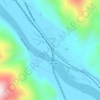
Name: Topografische Karte Paradise, Höhe, Relief.
Ort: Paradise, Sanders County, Montana, United States (47.38006 -114.80703 47.39195 -114.78914)
Durchschnittliche Höhe: 881 m
Minimale Höhe: 749 m
Maximale Höhe: 1’467 m
Spenden
Rüste dich für dein nächstes Abenteuer:
Als Amazon-Partner verdient diese Seite an qualifizierten Käufen, ohne dass Ihnen zusätzliche Kosten entstehen.