
Spenden
Rüste dich für dein nächstes Abenteuer:
Als Amazon-Partner verdient diese Seite an qualifizierten Käufen, ohne dass Ihnen zusätzliche Kosten entstehen.
Topografische Karte Primrose Lake
Klicken Sie auf die Karte, um die Höhe anzuzeigen.
Spenden
Rüste dich für dein nächstes Abenteuer:
Als Amazon-Partner verdient diese Seite an qualifizierten Käufen, ohne dass Ihnen zusätzliche Kosten entstehen.
Primrose Lake
Primrose Lake has a total surface area of 444 km2 (171 sq mi), 17.7 km2 (6.8 sq mi) of which is in Alberta, and an elevation of 559 metres (1,834 ft). It lies within muskeg and the boreal forest ecozone of Canada. There are several rivers and creeks that flow into the lake with Calder River on the northern shore being the primary inflow. Martineau River is the lake's outflow and it starts on the southern shore and flows in a south-westerly direction into Cold Lake in Alberta. To the east of the lake are the Mostoos Hills. Besides the aforementioned Martineau River and Cold Lake, the waters of Primrose Lake flow through multiple rivers and lakes en route to the Churchill River, including Cold River, Pierce Lake, Lepine Lake, Lac des Îles, Waterhen River, Waterhen Lake, Beaver River, and Lac Île-à-la-Crosse.
Spenden
Rüste dich für dein nächstes Abenteuer:
Als Amazon-Partner verdient diese Seite an qualifizierten Käufen, ohne dass Ihnen zusätzliche Kosten entstehen.
Über diese Karte
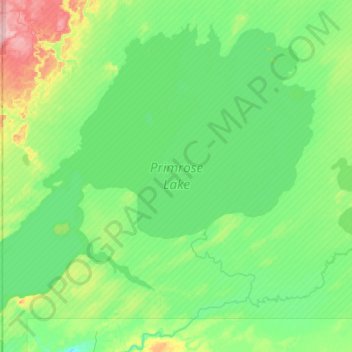
Name: Topografische Karte Primrose Lake, Höhe, Relief.
Durchschnittliche Höhe: 607 m
Minimale Höhe: 578 m
Maximale Höhe: 719 m
Spenden
Rüste dich für dein nächstes Abenteuer:
Als Amazon-Partner verdient diese Seite an qualifizierten Käufen, ohne dass Ihnen zusätzliche Kosten entstehen.
Andere topografische Karten
Klicken Sie auf eine Karte, um ihre Topografie, ihre Höhe und ihr Relief anzuzeigen.
Otter Lake
Canada > Saskatchewan > Unorganized Division No. 18 > Missinipe
Durchschnittliche Höhe: 369 m
Athabasca Sand Dunes
Canada > Saskatchewan > Unorganized Division No. 18
Durchschnittliche Höhe: 246 m
Spenden
Rüste dich für dein nächstes Abenteuer:
Als Amazon-Partner verdient diese Seite an qualifizierten Käufen, ohne dass Ihnen zusätzliche Kosten entstehen.
Spenden
Rüste dich für dein nächstes Abenteuer:
Als Amazon-Partner verdient diese Seite an qualifizierten Käufen, ohne dass Ihnen zusätzliche Kosten entstehen.
Cree Lake
Canada > Saskatchewan > Unorganized Division No. 18
Cree Lake is the remnant of a much larger proglacial lake. The proglacial lake was formed by the meltwaters of retreating continental glaciers during the last ice age about 8,700 years ago. This proglacial lake flowed south into the Churchill River drainage basin via glacial spillways. After the retreat of the…
Durchschnittliche Höhe: 508 m
Spenden
Rüste dich für dein nächstes Abenteuer:
Als Amazon-Partner verdient diese Seite an qualifizierten Käufen, ohne dass Ihnen zusätzliche Kosten entstehen.