
Topografische Karte Jersey City
Interaktive Karte
Klicken Sie auf die Karte, um die Höhe anzuzeigen.
Über diese Karte
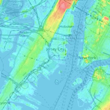
Name: Topografische Karte Jersey City, Höhe, Relief.
Ort: Jersey City, Hudson County, New Jersey, United States (40.66162 -74.11669 40.76894 -74.02064)
Durchschnittliche Höhe: 9 m
Minimale Höhe: -8 m
Maximale Höhe: 80 m
Jersey City (and most of Hudson County) is located on the peninsula known as Bergen Neck, with a waterfront on the east at the Hudson River and New York Bay and on the west at the Hackensack River and Newark Bay. Its north–south axis corresponds with the ridge of Bergen Hill, the emergence of the Hudson Palisades. The city is the site of some of the earliest European settlements in North America, which grew into each other rather than expanding from a central point. This growth and the topography greatly influenced the development of the sections of the city and its various neighborhoods.
Andere topografische Karten
Klicken Sie auf eine Karte, um ihre Topografie, ihre Höhe und ihr Relief anzuzeigen.
Secaucus
United States > New Jersey > Hudson County
Secaucus, Hudson County, New Jersey, United States
Durchschnittliche Höhe: 13 m
Hoboken
United States > New Jersey > Hudson County
Hoboken, Hudson County, New Jersey, United States
Durchschnittliche Höhe: 14 m
Jersey City
United States > New Jersey > Hudson County > Jersey City
Jersey City, Hudson County, New Jersey, 07302, United States
Durchschnittliche Höhe: 21 m