
Topografische Karte Blue Ridge
Interaktive Karte
Klicken Sie auf die Karte, um die Höhe anzuzeigen.
Über diese Karte
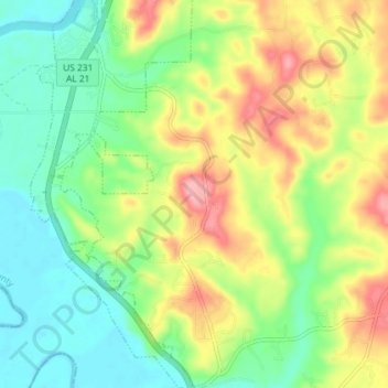
Name: Topografische Karte Blue Ridge, Höhe, Relief.
Ort: Blue Ridge, Elmore County, Alabama, United States (32.46914 -86.21600 32.53016 -86.15728)
Durchschnittliche Höhe: 88 m
Minimale Höhe: 39 m
Maximale Höhe: 164 m
Andere topografische Karten
Klicken Sie auf eine Karte, um ihre Topografie, ihre Höhe und ihr Relief anzuzeigen.
Greer
United States > Alabama > Elmore County
Greer, Elmore County, Alabama, United States
Durchschnittliche Höhe: 150 m
Wetumpka
United States > Alabama > Elmore County
Wetumpka, Elmore County, Alabama, United States
Durchschnittliche Höhe: 77 m
Old Bingham
United States > Alabama > Elmore County
Old Bingham, Elmore County, Alabama, United States
Durchschnittliche Höhe: 62 m
Deatsville
United States > Alabama > Elmore County
Deatsville, Elmore County, Alabama, 36022, United States
Durchschnittliche Höhe: 114 m
Tallassee
United States > Alabama > Elmore County
Tallassee, Elmore County, Alabama, United States
Durchschnittliche Höhe: 98 m
Ware
United States > Alabama > Elmore County > Ware
Ware, Elmore County, Alabama, United States
Durchschnittliche Höhe: 106 m
Eclectic
United States > Alabama > Elmore County > Eclectic
Eclectic, Elmore County, Alabama, 35024, United States
Durchschnittliche Höhe: 158 m
Jasmine Hill
United States > Alabama > Elmore County > Jasmine Hill
Jasmine Hill, Elmore County, Alabama, 36093, United States
Durchschnittliche Höhe: 97 m