
Topografische Karte Boyd
Interaktive Karte
Klicken Sie auf die Karte, um die Höhe anzuzeigen.
Über diese Karte
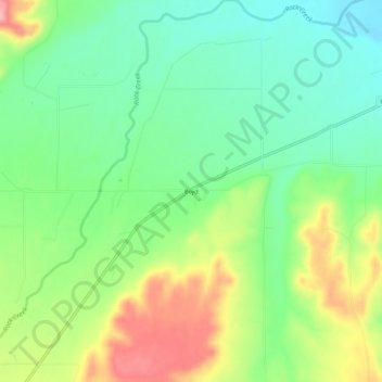
Name: Topografische Karte Boyd, Höhe, Relief.
Ort: Boyd, Carbon County, Montana, 59013, United States (45.43772 -109.08654 45.47772 -109.04654)
Durchschnittliche Höhe: 1’239 m
Minimale Höhe: 1’182 m
Maximale Höhe: 1’335 m
Andere topografische Karten
Klicken Sie auf eine Karte, um ihre Topografie, ihre Höhe und ihr Relief anzuzeigen.
Red Lodge
United States > Montana > Carbon County
Red Lodge, Carbon County, Montana, 59068, United States
Durchschnittliche Höhe: 1’720 m
Luther
United States > Montana > Carbon County
Luther, Carbon County, Montana, United States
Durchschnittliche Höhe: 1’604 m
Joliet
United States > Montana > Carbon County
Joliet, Carbon County, Montana, 59041, United States
Durchschnittliche Höhe: 1’162 m