
Topografische Karte Fort Atkinson
Interaktive Karte
Klicken Sie auf die Karte, um die Höhe anzuzeigen.
Über diese Karte
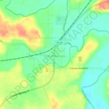
Name: Topografische Karte Fort Atkinson, Höhe, Relief.
Ort: Fort Atkinson, Winneshiek County, Iowa, United States (43.13956 -91.94147 43.14787 -91.92648)
Durchschnittliche Höhe: 321 m
Minimale Höhe: 299 m
Maximale Höhe: 351 m
Andere topografische Karten
Klicken Sie auf eine Karte, um ihre Topografie, ihre Höhe und ihr Relief anzuzeigen.
Ossian
United States > Iowa > Winneshiek County
Ossian, Winneshiek County, Iowa, United States
Durchschnittliche Höhe: 375 m
Freeport
United States > Iowa > Winneshiek County
Freeport, Winneshiek County, Iowa, 52101, United States
Durchschnittliche Höhe: 299 m
Decorah
United States > Iowa > Winneshiek County
Decorah, Winneshiek County, Iowa, United States
Durchschnittliche Höhe: 309 m
Ridgeway
United States > Iowa > Winneshiek County
Ridgeway, Winneshiek County, Iowa, United States
Durchschnittliche Höhe: 364 m
Calmar
United States > Iowa > Winneshiek County
Calmar, Winneshiek County, Iowa, United States
Durchschnittliche Höhe: 376 m