
Topografische Karte Turhal
Interaktive Karte
Klicken Sie auf die Karte, um die Höhe anzuzeigen.
Über diese Karte
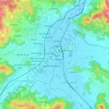
Name: Topografische Karte Turhal, Höhe, Relief.
Ort: Turhal, Tokat, Black Sea Region, 60300, Turkey (40.34615 36.04792 40.42615 36.12792)
Durchschnittliche Höhe: 599 m
Minimale Höhe: 527 m
Maximale Höhe: 947 m
Turhal is a town and a district of Tokat Province in the Black Sea region of Turkey. It is 48 km in the west of Tokat Province. Turhal is situated on a fertile plain fragmented by the Yeşil Irmak river. It has an elevation of approximately 530 m. The city is best known for its sugar beet processing plant established in 1934 as an important enterprise of the young Turkish Republic. The mayor is Yılmaz Bekler (AKP).