
Topografische Karte Frostburg
Interaktive Karte
Klicken Sie auf die Karte, um die Höhe anzuzeigen.
Über diese Karte
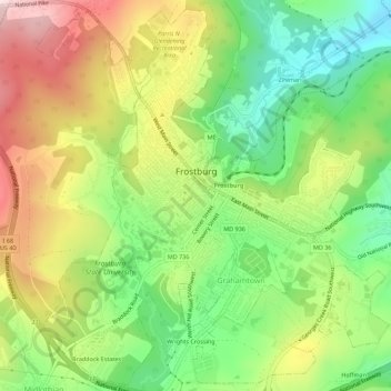
Name: Topografische Karte Frostburg, Höhe, Relief.
Ort: Frostburg, Allegany County, Maryland, 21532, United States (39.63471 -78.95116 39.67617 -78.90082)
Durchschnittliche Höhe: 620 m
Minimale Höhe: 456 m
Maximale Höhe: 822 m
Due to its average elevation of 2,000 feet (610 m) above sea level and location near the Allegheny Front, Frostburg has a colder, wetter climate than much of the rest of the state, and falls in USDA hardiness zone 6b. Under the Köppen climate classification, it has a humid continental climate (Dfb), with cold, snowy winters, and warm, humid summers. The daily mean temperature ranges from 26.0 °F (−3.3 °C) in January to 69.0 °F (20.6 °C) in July. Sub-0 °F (−18 °C) occur on 3.8 nights per year, while, on average, there are 1.4 days with 90 °F (32 °C)+ highs, though these are not recorded every year. Due to orographic lift, driving conditions on I-68 and US 40 can be very hazardous despite timely state and local road maintenance services, and the town averages just over 80 inches (200 cm) of snowfall a season; significant falls can occur as early as October and as late as May. Frostburg's greatest one-month snowfall was 67 inches (170 cm) in January 1978, and Frostburg is second in Maryland for the greatest single-season snowfall with a total of 180 inches (460 cm) in the winter of 1995−96.