
Topografische Karte Hinchinbrook Island
Interaktive Karte
Klicken Sie auf die Karte, um die Höhe anzuzeigen.
Über diese Karte
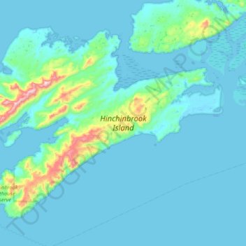
Name: Topografische Karte Hinchinbrook Island, Höhe, Relief.
Durchschnittliche Höhe: 68 m
Minimale Höhe: -9 m
Maximale Höhe: 870 m
Andere topografische Karten
Klicken Sie auf eine Karte, um ihre Topografie, ihre Höhe und ihr Relief anzuzeigen.
Delta Road
United States of America > Alaska > King Cove
Delta Road, King Cove, Aleutians East, Alaska, United States of America
Durchschnittliche Höhe: 119 m
Denali National Park and Preserve
United States of America > Alaska
Denali National Park and Preserve, Alaska, United States of America
Durchschnittliche Höhe: 777 m
Glacier Bay National Park
United States of America > Alaska
Glacier Bay National Park, Unorganized Borough, Alaska, United States of America
Durchschnittliche Höhe: 572 m
Prudhoe Bay
United States of America > Alaska > Prudhoe Bay
Prudhoe Bay, North Slope, Alaska, 99734, United States of America
Durchschnittliche Höhe: 10 m