
Spenden
Rüste dich für dein nächstes Abenteuer:
Als Amazon-Partner verdient diese Seite an qualifizierten Käufen, ohne dass Ihnen zusätzliche Kosten entstehen.
Topografische Karte Port Angeles
Klicken Sie auf die Karte, um die Höhe anzuzeigen.
Spenden
Rüste dich für dein nächstes Abenteuer:
Als Amazon-Partner verdient diese Seite an qualifizierten Käufen, ohne dass Ihnen zusätzliche Kosten entstehen.
Port Angeles
Port Angeles is characterized by a diverse and dramatic topography that reflects its unique geographic position on the Olympic Peninsula. Situated at approximately 72 feet above sea level, the city rises from the shores of the Strait of Juan de Fuca and is bordered by the Olympic Mountains to the south, which soar to elevations exceeding 7,000 feet. This mountainous backdrop is notable for its steep slopes and deep valleys, shaped by glacial activity and erosion. The surrounding landscape features a mixture of rugged terrain and lush forests, with numerous rivers and streams that traverse the area, enhancing its scenic beauty and providing habitats for local wildlife. Additionally, the coastline is marked by rocky shorelines and sandy beaches, creating a rich environment for both recreation and biodiversity.
Spenden
Rüste dich für dein nächstes Abenteuer:
Als Amazon-Partner verdient diese Seite an qualifizierten Käufen, ohne dass Ihnen zusätzliche Kosten entstehen.
Über diese Karte
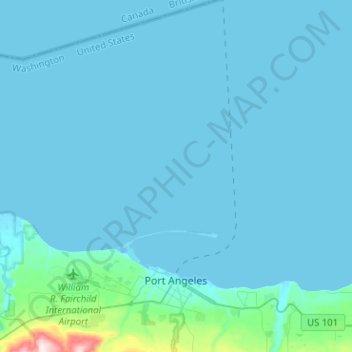
Name: Topografische Karte Port Angeles, Höhe, Relief.
Durchschnittliche Höhe: 27 m
Minimale Höhe: -6 m
Maximale Höhe: 501 m
Spenden
Rüste dich für dein nächstes Abenteuer:
Als Amazon-Partner verdient diese Seite an qualifizierten Käufen, ohne dass Ihnen zusätzliche Kosten entstehen.
Andere topografische Karten
Klicken Sie auf eine Karte, um ihre Topografie, ihre Höhe und ihr Relief anzuzeigen.
Olympic Peninsula Gardens
United States > Washington > Clallam County > Sequim
Durchschnittliche Höhe: 45 m
Spenden
Rüste dich für dein nächstes Abenteuer:
Als Amazon-Partner verdient diese Seite an qualifizierten Käufen, ohne dass Ihnen zusätzliche Kosten entstehen.
Spenden
Rüste dich für dein nächstes Abenteuer:
Als Amazon-Partner verdient diese Seite an qualifizierten Käufen, ohne dass Ihnen zusätzliche Kosten entstehen.
Spenden
Rüste dich für dein nächstes Abenteuer:
Als Amazon-Partner verdient diese Seite an qualifizierten Käufen, ohne dass Ihnen zusätzliche Kosten entstehen.