
Topografische Karte Fresnay-sur-Sarthe
Interaktive Karte
Klicken Sie auf die Karte, um die Höhe anzuzeigen.
Über diese Karte
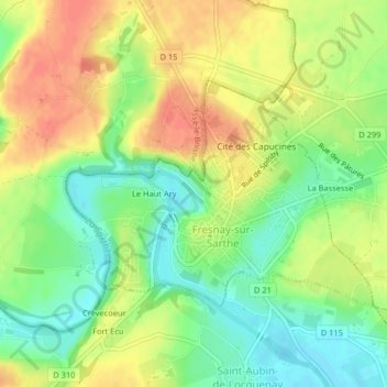
Name: Topografische Karte Fresnay-sur-Sarthe, Höhe, Relief.
Durchschnittliche Höhe: 95 m
Minimale Höhe: 69 m
Maximale Höhe: 120 m
Andere topografische Karten
Klicken Sie auf eine Karte, um ihre Topografie, ihre Höhe und ihr Relief anzuzeigen.
Saint-Germain-sur-Sarthe
France > Pays de la Loire > Sarthe > Fresnay-sur-Sarthe
Saint-Germain-sur-Sarthe, Fresnay-sur-Sarthe, Mamers, Sarthe, Pays de la Loire, France métropolitaine, 72130, France
Durchschnittliche Höhe: 82 m
Le Haut Ary
France > Pays de la Loire > Sarthe > Fresnay-sur-Sarthe
Le Haut Ary, Fresnay-sur-Sarthe, Mamers, Sarthe, Pays de la Loire, France métropolitaine, 72130, France
Durchschnittliche Höhe: 96 m
Coulombiers
France > Pays de la Loire > Sarthe > Fresnay-sur-Sarthe
Coulombiers, Fresnay-sur-Sarthe, Mamers, Sarthe, Pays de la Loire, France métropolitaine, 72130, France
Durchschnittliche Höhe: 91 m