
Spenden
Rüste dich für dein nächstes Abenteuer:
Als Amazon-Partner verdient diese Seite an qualifizierten Käufen, ohne dass Ihnen zusätzliche Kosten entstehen.
Topografische Karte Koloriang
Klicken Sie auf die Karte, um die Höhe anzuzeigen.
Spenden
Rüste dich für dein nächstes Abenteuer:
Als Amazon-Partner verdient diese Seite an qualifizierten Käufen, ohne dass Ihnen zusätzliche Kosten entstehen.
Koloriang
Koloriang is a hilly district headquarters town of Kurung Kumey district in Arunachal Pradesh, India, bordering Tibet. It has an altitude of 1,000 metres (3,300 ft) and is surrounded by high mountains all around and is located in the right bank of river Kurung, one of the major tributaries of Subansiri river. The climate is rainy and hot during summer and very cold in winter. Located at an altitude of 1,040 metres above sea level, this town is also an old administrative centre. It is about 257 km from state capital, Itanagar.
Spenden
Rüste dich für dein nächstes Abenteuer:
Als Amazon-Partner verdient diese Seite an qualifizierten Käufen, ohne dass Ihnen zusätzliche Kosten entstehen.
Über diese Karte
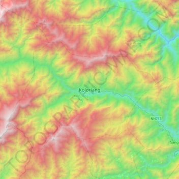
Name: Topografische Karte Koloriang, Höhe, Relief.
Durchschnittliche Höhe: 1’791 m
Minimale Höhe: 498 m
Maximale Höhe: 3’508 m
Spenden
Rüste dich für dein nächstes Abenteuer:
Als Amazon-Partner verdient diese Seite an qualifizierten Käufen, ohne dass Ihnen zusätzliche Kosten entstehen.