Geolokalisieren

Topografische Karte Kinlet

Klicken Sie auf die Karte, um die Höhe anzuzeigen.

Über diese Karte

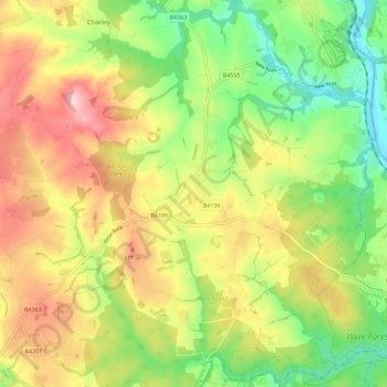
Name: Topografische Karte Kinlet, Höhe, Relief.

Ort: Kinlet, Shropshire, England, United Kingdom (52.38151 -2.44690 52.45071 -2.33359)

Durchschnittliche Höhe: 118 m

Minimale Höhe: 22 m

Maximale Höhe: 230 m

Andere topografische Karten

Klicken Sie auf eine Karte, um ihre Topografie, ihre Höhe und ihr Relief anzuzeigen.

Carding Mill

United Kingdom > England > Shropshire > Church Stretton

Durchschnittliche Höhe: 328 m

Ron Hill

United Kingdom > England > Shropshire > Cleobury Mortimer

Durchschnittliche Höhe: 144 m

Stanmore Country Park

United Kingdom > England > Shropshire > Quatford

Durchschnittliche Höhe: 81 m

Callow Hill

United Kingdom > England > Shropshire > Diddlebury

Durchschnittliche Höhe: 215 m

Whitchurch

United Kingdom > England > Shropshire

Durchschnittliche Höhe: 100 m

Oswestry

United Kingdom > England > Shropshire

Durchschnittliche Höhe: 158 m

Clun

United Kingdom > England > Shropshire

Durchschnittliche Höhe: 284 m

Dudleston

United Kingdom > England > Shropshire

Durchschnittliche Höhe: 100 m

Brownhill

United Kingdom > England > Shropshire > Ruyton-XI-Towns

Durchschnittliche Höhe: 95 m

Calcott

United Kingdom > England > Shropshire > Bicton

Durchschnittliche Höhe: 77 m

Treflach

United Kingdom > England > Shropshire

Durchschnittliche Höhe: 176 m

Coundmoor

United Kingdom > England > Shropshire

Durchschnittliche Höhe: 107 m

Croesau Bach

United Kingdom > England > Shropshire > Trefonen

Durchschnittliche Höhe: 247 m

Chavel

United Kingdom > England > Shropshire > Ford

Durchschnittliche Höhe: 83 m

Bletchley

United Kingdom > England > Shropshire

Durchschnittliche Höhe: 83 m

Comley

United Kingdom > England > Shropshire > Cardington > Comley

Durchschnittliche Höhe: 223 m

Alberbury

United Kingdom > England > Shropshire

Durchschnittliche Höhe: 88 m

Plaish

United Kingdom > England > Shropshire > Cardington

Durchschnittliche Höhe: 208 m

Whitcliffe

United Kingdom > England > Shropshire > Ludford

Durchschnittliche Höhe: 132 m

Lower Forge

United Kingdom > England > Shropshire > Eardington

Durchschnittliche Höhe: 69 m

Park Hall

United Kingdom > England > Shropshire

Durchschnittliche Höhe: 112 m

Nantmawr

United Kingdom > England > Shropshire

Durchschnittliche Höhe: 166 m

Sleap

United Kingdom > England > Shropshire > Wem

Durchschnittliche Höhe: 85 m

Overton

United Kingdom > England > Shropshire

Durchschnittliche Höhe: 136 m

Maesbrook

United Kingdom > England > Shropshire

Durchschnittliche Höhe: 66 m

Weston

United Kingdom > England > Shropshire > Oswestry

Durchschnittliche Höhe: 114 m

Burrow

United Kingdom > England > Shropshire > Hopesay

Durchschnittliche Höhe: 218 m

Pant-glas

United Kingdom > England > Shropshire > Oswestry

Durchschnittliche Höhe: 223 m

Brown Clee Hill

United Kingdom > England > Shropshire

Durchschnittliche Höhe: 385 m

Bushmoor

United Kingdom > England > Shropshire

Durchschnittliche Höhe: 189 m

Meadowtown

United Kingdom > England > Shropshire

Durchschnittliche Höhe: 218 m

Snailbeach

United Kingdom > England > Shropshire

Durchschnittliche Höhe: 248 m

Cothercott Hill

United Kingdom > England > Shropshire > Church Pulverbatch

Durchschnittliche Höhe: 342 m

Lyth Hill

United Kingdom > England > Shropshire > Longden

Durchschnittliche Höhe: 108 m

Soudley

United Kingdom > England > Shropshire > Cheswardine

Durchschnittliche Höhe: 116 m

Newton

United Kingdom > England > Shropshire > Ellesmere

Durchschnittliche Höhe: 99 m

Stiperstones

United Kingdom > England > Shropshire

Durchschnittliche Höhe: 401 m

Kenstone

United Kingdom > England > Shropshire > Hodnet

Durchschnittliche Höhe: 122 m

Pennerley

United Kingdom > England > Shropshire > Stiperstones

Durchschnittliche Höhe: 353 m

Dryton

United Kingdom > England > Shropshire > Eyton on Severn

Durchschnittliche Höhe: 70 m

The Lawley

United Kingdom > England > Shropshire

Durchschnittliche Höhe: 217 m

Strefford

United Kingdom > England > Shropshire > Wistanstow

It lies in the civil parish of Wistanstow and is situated just off the A49 road, 2 miles (3.2 km) north of the small town of Craven Arms. The nearest settlement is Upper Affcot, a hamlet located north of the A49, with a public house. Strefford is situated at an elevation between 130 metres (430 ft) and 135m,…

Durchschnittliche Höhe: 175 m

Prees Higher Heath

United Kingdom > England > Shropshire

Durchschnittliche Höhe: 92 m

Bridges

United Kingdom > England > Shropshire

Durchschnittliche Höhe: 333 m

Darliston

United Kingdom > England > Shropshire > Prees Lower Heath

Durchschnittliche Höhe: 90 m

Knowbury

United Kingdom > England > Shropshire

Durchschnittliche Höhe: 225 m

Wolverley

United Kingdom > England > Shropshire > Newtown

Durchschnittliche Höhe: 88 m

Wern

United Kingdom > England > Shropshire > Weston Rhyn

Durchschnittliche Höhe: 162 m

Calverhall

United Kingdom > England > Shropshire

Durchschnittliche Höhe: 99 m

Derrington

United Kingdom > England > Shropshire > Ditton Priors

Durchschnittliche Höhe: 219 m

Selattyn

United Kingdom > England > Shropshire

Durchschnittliche Höhe: 242 m

Myddle

United Kingdom > England > Shropshire

Durchschnittliche Höhe: 94 m

Ellesmere

United Kingdom > England > Shropshire

Durchschnittliche Höhe: 94 m

Ash Magna

United Kingdom > England > Shropshire

Durchschnittliche Höhe: 108 m

Minton

United Kingdom > England > Shropshire > Church Stretton > Little Stretton

Durchschnittliche Höhe: 272 m

Pipe Gate

United Kingdom > England > Shropshire

Durchschnittliche Höhe: 128 m

Walford Heath

United Kingdom > England > Shropshire > Walford

Durchschnittliche Höhe: 84 m

Hanwood Bank

United Kingdom > England > Shropshire > Hanwood

Durchschnittliche Höhe: 92 m

Farmcote

United Kingdom > England > Shropshire > Claverley

Durchschnittliche Höhe: 96 m

Brockton

United Kingdom > England > Shropshire

Durchschnittliche Höhe: 213 m

Plealey

United Kingdom > England > Shropshire

Durchschnittliche Höhe: 126 m

Little Stretton

United Kingdom > England > Shropshire > Church Stretton

Durchschnittliche Höhe: 270 m

Caer Caradoc

United Kingdom > England > Shropshire > Church Stretton

Durchschnittliche Höhe: 251 m

Trefonen

United Kingdom > England > Shropshire

Durchschnittliche Höhe: 204 m

Hook-a-Gate

United Kingdom > England > Shropshire

Durchschnittliche Höhe: 98 m

Maesbury

United Kingdom > England > Shropshire

Durchschnittliche Höhe: 90 m

Button Oak

United Kingdom > England > Shropshire

Durchschnittliche Höhe: 92 m

Burlton

United Kingdom > England > Shropshire

Durchschnittliche Höhe: 92 m

Pant

United Kingdom > England > Shropshire

Durchschnittliche Höhe: 97 m

Hope Bowdler Hill

United Kingdom > England > Shropshire

Durchschnittliche Höhe: 287 m

Lower Hengoed

United Kingdom > England > Shropshire > Gobowen

Durchschnittliche Höhe: 134 m

Longnor

United Kingdom > England > Shropshire

Durchschnittliche Höhe: 127 m

Oreton

United Kingdom > England > Shropshire

Durchschnittliche Höhe: 173 m

Abdon

United Kingdom > England > Shropshire

Durchschnittliche Höhe: 292 m

Wall under Heywood

United Kingdom > England > Shropshire

Durchschnittliche Höhe: 203 m

Burwarton

United Kingdom > England > Shropshire > Burwarton

Durchschnittliche Höhe: 267 m

Walford

United Kingdom > England > Shropshire

Durchschnittliche Höhe: 83 m

Allscott

United Kingdom > England > Shropshire

Durchschnittliche Höhe: 67 m

Sweeney Mountain

United Kingdom > England > Shropshire

Durchschnittliche Höhe: 136 m

Hopesay

United Kingdom > England > Shropshire

Durchschnittliche Höhe: 216 m

Wooton

United Kingdom > England > Shropshire

Durchschnittliche Höhe: 90 m

Cross Houses

United Kingdom > England > Shropshire

Durchschnittliche Höhe: 62 m

Middleton Priors

United Kingdom > England > Shropshire > Ditton Priors

Durchschnittliche Höhe: 220 m

Bronygarth

United Kingdom > England > Shropshire

Durchschnittliche Höhe: 196 m

Grimpo

United Kingdom > England > Shropshire

Durchschnittliche Höhe: 91 m

Kempton

United Kingdom > England > Shropshire

Durchschnittliche Höhe: 208 m

Stapeley Hill

United Kingdom > England > Shropshire

Durchschnittliche Höhe: 311 m

Farden

United Kingdom > England > Shropshire > Bitterley

Durchschnittliche Höhe: 245 m

Garmston

United Kingdom > England > Shropshire > Leighton

Durchschnittliche Höhe: 97 m

Preston Brockhurst

United Kingdom > England > Shropshire > Acton Reynald

Durchschnittliche Höhe: 99 m

Morda

United Kingdom > England > Shropshire

Durchschnittliche Höhe: 132 m

Colemere

United Kingdom > England > Shropshire

Durchschnittliche Höhe: 96 m

Bagginswood

United Kingdom > England > Shropshire > Stottesdon

Durchschnittliche Höhe: 160 m

Weston Lullingfields

United Kingdom > England > Shropshire

Durchschnittliche Höhe: 93 m

Stiperstones

United Kingdom > England > Shropshire

Durchschnittliche Höhe: 327 m

Wroxeter

United Kingdom > England > Shropshire

Durchschnittliche Höhe: 61 m

Marton

United Kingdom > England > Shropshire

Durchschnittliche Höhe: 92 m

Plowden

United Kingdom > England > Shropshire > Lydbury North

Durchschnittliche Höhe: 223 m

Quatford

United Kingdom > England > Shropshire > Bridgnorth

Durchschnittliche Höhe: 69 m

Highley

United Kingdom > England > Shropshire

Durchschnittliche Höhe: 80 m

Rüste dich für dein nächstes Abenteuer:

🧼Biologische Outdoor-Seife - Umweltfreundliche Hygiene in der Natur
🩹Blasenpflaster & Fußpflege - Erste Hilfe für Füße bei langen Touren
🥣Camping‑Bestecksets - Leichte Bestecksets für Touren
🧣Merinoschals - Kratzfreie Wärme für den Halsbereich
🔪Schweizer Taschenmesser - Das unverzichtbare Werkzeug für jede Wanderung

Als Amazon-Partner verdient diese Seite an qualifizierten Käufen, ohne dass Ihnen zusätzliche Kosten entstehen.