
Topografische Karte Swainson Island
Interaktive Karte
Klicken Sie auf die Karte, um die Höhe anzuzeigen.
Über diese Karte
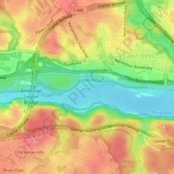
Name: Topografische Karte Swainson Island, Höhe, Relief.
Durchschnittliche Höhe: 52 m
Minimale Höhe: 9 m
Maximale Höhe: 85 m
Andere topografische Karten
Klicken Sie auf eine Karte, um ihre Topografie, ihre Höhe und ihr Relief anzuzeigen.
Severn River
USA > Maryland > Epping Forest
Severn River, Severn Road, Parole, Epping Forest, Anne Arundel County, Maryland, 21405, USA
Durchschnittliche Höhe: 13 m
Kingsville
USA > Maryland > Kingsville
Kingsville, Baltimore County, Maryland, 21087, USA
Durchschnittliche Höhe: 83 m
Savage River
Savage River, Garrett County, Maryland, 21523, USA
Durchschnittliche Höhe: 687 m
Henrys Bridge
USA > Maryland > Henrys Bridge
Henrys Bridge, Baltimore County, Maryland, 21131, USA
Durchschnittliche Höhe: 165 m
Grahams Green Acres
USA > Maryland > Grahams Green Acres
Grahams Green Acres, Carroll County, Maryland, 21776, USA
Durchschnittliche Höhe: 223 m
Sue Island
Sue Island, Towson, Baltimore County, Maryland, 21220-5203, USA
Durchschnittliche Höhe: 47 m
Deal Island
Deal Island, Somerset County, Maryland, 21821, USA
Durchschnittliche Höhe: 2 m
Sugarloaf Mountain
Sugarloaf Mountain, Frederick County, Maryland, 20842, USA
Durchschnittliche Höhe: 200 m
Chesapeake Bay
Chesapeake Bay, Dorchester County, Maryland, USA
Durchschnittliche Höhe: 0 m