
Topografische Karte Tinum
Interaktive Karte
Klicken Sie auf die Karte, um die Höhe anzuzeigen.
Über diese Karte
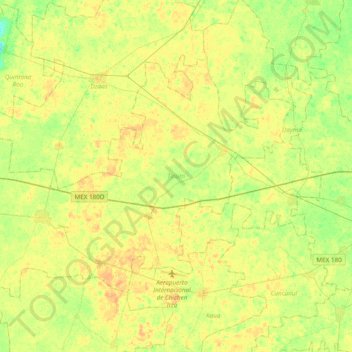
Name: Topografische Karte Tinum, Höhe, Relief.
Ort: Tinum, Yucatán, 97751, México (20.61735 -88.69644 20.86497 -88.31328)
Durchschnittliche Höhe: 25 m
Minimale Höhe: 12 m
Maximale Höhe: 34 m
Andere topografische Karten
Klicken Sie auf eine Karte, um ihre Topografie, ihre Höhe und ihr Relief anzuzeigen.
San Ignacio
México > Yucatán > San Ignacio
San Ignacio, Progreso, Yucatán, México
Durchschnittliche Höhe: 5 m
San Felipe Nuevo
México > Yucatán > San Felipe Nuevo
San Felipe Nuevo, Tinum, Yucatán, 97751, México
Durchschnittliche Höhe: 27 m
José María Morelos y Pavón
México > Yucatán > José María Morelos y Pavón
José María Morelos y Pavón, Teya, Yucatán, México
Durchschnittliche Höhe: 9 m