
Topografische Karte Nowy Targ
Interaktive Karte
Klicken Sie auf die Karte, um die Höhe anzuzeigen.
Über diese Karte
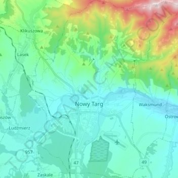
Name: Topografische Karte Nowy Targ, Höhe, Relief.
Durchschnittliche Höhe: 679 m
Minimale Höhe: 567 m
Maximale Höhe: 1’135 m
According to the Köppen climate classification, Nowy Targ straddles the border of the Warm Summer Continental (Dfb) and Subarctic (Dfc) climates, with most of the city falling in the Dfb group. The Dfc climate is only found above 800 metres of elevation within Nowy Targ.