
Topografische Karte Ponnal
Klicken Sie auf die Karte, um die Höhe anzuzeigen.
Über diese Karte
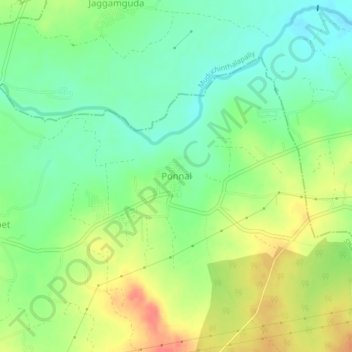
Name: Topografische Karte Ponnal, Höhe, Relief.
Ort: Ponnal, Shamirpet mandal, Medchal–Malkajgiri, Telangana, India (17.58488 78.61209 17.62488 78.65209)
Durchschnittliche Höhe: 546 m
Minimale Höhe: 522 m
Maximale Höhe: 579 m
Andere topografische Karten
Klicken Sie auf eine Karte, um ihre Topografie, ihre Höhe und ihr Relief anzuzeigen.
Hyderabad
India > Telangana > Bahadurpura mandal
Hyderabad (/ˈhaɪdərəbæd/ HY-dər-ə-bad; Telugu: [ˈɦaɪ̯daraːbaːd], Urdu: [ˈɦɛːdəɾaːbaːd]) is the capital and largest city of the Indian state of Telangana. It occupies 650 km2 (250 sq mi) on the Deccan Plateau along the banks of the Musi River, in the northern part of Southern India. With an…
Durchschnittliche Höhe: 549 m