
Topografische Karte Laurel
Interaktive Karte
Klicken Sie auf die Karte, um die Höhe anzuzeigen.
Über diese Karte
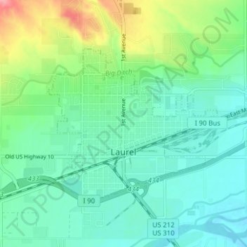
Name: Topografische Karte Laurel, Höhe, Relief.
Ort: Laurel, Yellowstone County, Montana, United States (45.66104 -108.79056 45.68737 -108.72821)
Durchschnittliche Höhe: 1’019 m
Minimale Höhe: 992 m
Maximale Höhe: 1’093 m
Andere topografische Karten
Klicken Sie auf eine Karte, um ihre Topografie, ihre Höhe und ihr Relief anzuzeigen.
Billings
United States > Montana > Yellowstone County
Billings, Yellowstone County, Montana, United States
Durchschnittliche Höhe: 1’023 m
Huntley
United States > Montana > Yellowstone County
Huntley, Yellowstone County, Montana, United States
Durchschnittliche Höhe: 924 m
Yegen
United States > Montana > Yellowstone County
Yegen, Yellowstone County, Montana, United States
Durchschnittliche Höhe: 981 m