
Spenden
Rüste dich für dein nächstes Abenteuer:
Als Amazon-Partner verdient diese Seite an qualifizierten Käufen, ohne dass Ihnen zusätzliche Kosten entstehen.
Topografische Karte Quemado
Klicken Sie auf die Karte, um die Höhe anzuzeigen.
Spenden
Rüste dich für dein nächstes Abenteuer:
Als Amazon-Partner verdient diese Seite an qualifizierten Käufen, ohne dass Ihnen zusätzliche Kosten entstehen.
Über diese Karte
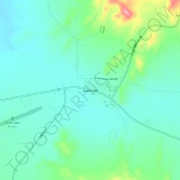
Name: Topografische Karte Quemado, Höhe, Relief.
Ort: Quemado, Catron County, New Mexico, 87829, United States (34.32360 -108.51831 34.36360 -108.47831)
Durchschnittliche Höhe: 2’113 m
Minimale Höhe: 2’079 m
Maximale Höhe: 2’226 m
Spenden
Rüste dich für dein nächstes Abenteuer:
Als Amazon-Partner verdient diese Seite an qualifizierten Käufen, ohne dass Ihnen zusätzliche Kosten entstehen.
Andere topografische Karten
Klicken Sie auf eine Karte, um ihre Topografie, ihre Höhe und ihr Relief anzuzeigen.
Gila Wilderness
United States > New Mexico > Catron County
The Gila Wilderness is located in southwest New Mexico, north of Silver City and east of Reserve. It contains the West Fork, Middle Fork and much of the East Fork of the Gila River; riverside elevations of around 4,850 feet (1,480 m) are the lowest in the wilderness. The Mogollon Mountains traverse an arc…
Durchschnittliche Höhe: 2’085 m
Reserve
United States > New Mexico > Catron County
Reserve has a Mediterranean climate of the warm-summer type (Köppen: Csb), unusual in New Mexico. Despite having mild to hot daytime highs year round, temperatures substantially cool off during nighttime due to Reserve's high elevation and aridity. Even in the summertime, 90 degree days can cool off into the…
Durchschnittliche Höhe: 1’780 m
Gila Wilderness
United States > New Mexico > Catron County
The Gila Wilderness is located in southwest New Mexico, north of Silver City and east of Reserve. It contains the West Fork, Middle Fork and much of the East Fork of the Gila River; riverside elevations of around 4,850 feet (1,480 m) are the lowest in the wilderness. The Mogollon Mountains traverse an arc…
Durchschnittliche Höhe: 2’085 m
Spenden
Rüste dich für dein nächstes Abenteuer:
Als Amazon-Partner verdient diese Seite an qualifizierten Käufen, ohne dass Ihnen zusätzliche Kosten entstehen.