
Topografische Karte Trevélez
Interaktive Karte
Klicken Sie auf die Karte, um die Höhe anzuzeigen.
Über diese Karte
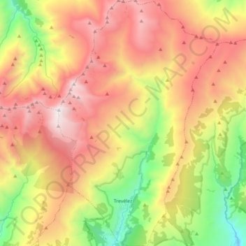
Name: Topografische Karte Trevélez, Höhe, Relief.
Durchschnittliche Höhe: 2’351 m
Minimale Höhe: 1’206 m
Maximale Höhe: 3’473 m
Located at a height of 1486 metres, Trevélez is not the highest recognised municipality in Spain. That honour goes to Valdelinares located in the Sierra de Gúdar range of the Sistema Ibérico, in the province of Teruel, Aragon, Spain. It lies at the confluence of the Río Trevélez with a smaller stream, to the southwest of Mulhacén, the highest peak of the Sierra Nevada and of the Iberian peninsula. The village lies to the west of the Río Trevélez. It is divided into three parts, the Barrios Bajo, Medio and Alto (lower, mid and upper quarters), with 200 metres of altitude difference between the highest and lowest points. The only bridge over the river is in the Barrio Bajo. The Barrio Bajo is a significant tourist centre, while the Barrios Medio and Alto are more typically Alpujarran in style, though tourism is important to the economy of the entire village. To the west, the nearest village is Busquístar; the road through the Bajo Barrio continues to the east and south to Juviles and Torvizcón. There is a regular bus service along this road, linking the village to the regional centres of Lanjarón and Órgiva as well as the provincial capital, Granada.
Andere topografische Karten
Klicken Sie auf eine Karte, um ihre Topografie, ihre Höhe und ihr Relief anzuzeigen.
Sierra Nevada
Spain > Andalusia > Comarca de la Alpujarra Granadina > Lanjarón
Sierra Nevada, Lanjarón, Comarca de la Alpujarra Granadina, Granada, Andalusia, Spain
Durchschnittliche Höhe: 2’223 m
Pico de Mulhacén
Spain > Andalusia > Comarca de la Alpujarra Granadina > Trevélez
Pico de Mulhacén, Trevélez, Comarca de la Alpujarra Granadina, Granada, Andalusia, Spain
Durchschnittliche Höhe: 3’070 m
Sierra Nevada
Spain > Andalusia > Comarca de la Alpujarra Granadina
Sierra Nevada, Comarca de la Alpujarra Granadina, Granada, Andalusia, Spain
Durchschnittliche Höhe: 1’321 m
Soportújar
Spain > Andalusia > Comarca de la Alpujarra Granadina
Soportújar, Comarca de la Alpujarra Granadina, Granada, Andalusia, 18410, Spain
Durchschnittliche Höhe: 1’867 m
Pico del Veleta
Spain > Andalusia > Comarca de la Alpujarra Granadina > Capileira
Pico del Veleta, Capileira, Comarca de la Alpujarra Granadina, Granada, Andalusia, Spain
Durchschnittliche Höhe: 2’998 m
Capileira
Spain > Andalusia > Comarca de la Alpujarra Granadina
Capileira, Comarca de la Alpujarra Granadina, Granada, Andalusia, 18413, Spain
Durchschnittliche Höhe: 2’384 m
Cáñar
Spain > Andalusia > Comarca de la Alpujarra Granadina > Cáñar
Cáñar, Comarca de la Alpujarra Granadina, Granada, Andalusia, Spain
Durchschnittliche Höhe: 1’816 m
Río Guadalfeo
Spain > Andalusia > Comarca de la Alpujarra Granadina
Río Guadalfeo, Comarca de la Alpujarra Granadina, Granada, Andalusia, 18440, Spain
Durchschnittliche Höhe: 853 m
Bubión
Spain > Andalusia > Comarca de la Alpujarra Granadina
Bubión, Comarca de la Alpujarra Granadina, Granada, Andalusia, 18412, Spain
Durchschnittliche Höhe: 2’129 m
Mecina Bombarón
Spain > Andalusia > Comarca de la Alpujarra Granadina > Alpujarra de la Sierra
Mecina Bombarón, Alpujarra de la Sierra, Comarca de la Alpujarra Granadina, Granada, Andalusia, 18450, Spain
Durchschnittliche Höhe: 1’292 m