
Topografische Karte Washington Township
Interaktive Karte
Klicken Sie auf die Karte, um die Höhe anzuzeigen.
Über diese Karte
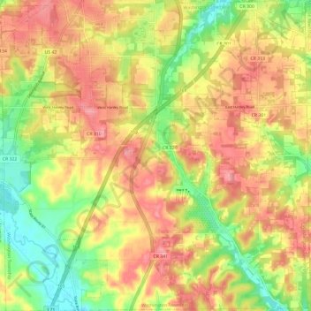
Name: Topografische Karte Washington Township, Höhe, Relief.
Ort: Washington Township, Richland County, Ohio, United States (40.63744 -82.57068 40.72666 -82.45315)
Durchschnittliche Höhe: 406 m
Minimale Höhe: 344 m
Maximale Höhe: 458 m
Andere topografische Karten
Klicken Sie auf eine Karte, um ihre Topografie, ihre Höhe und ihr Relief anzuzeigen.
Shenandoah
United States > Ohio > Richland County
Shenandoah, Blooming Grove Township, Richland County, Ohio, 44878, United States
Durchschnittliche Höhe: 350 m
Olivesburg
United States > Ohio > Richland County
Olivesburg, Weller Township, Richland County, Ohio, United States
Durchschnittliche Höhe: 348 m
Vernon Junction
United States > Ohio > Richland County
Vernon Junction, Sharon Township, Richland County, Ohio, 44875, United States
Durchschnittliche Höhe: 344 m
Mansfield
United States > Ohio > Richland County
Mansfield, Richland County, Ohio, United States
Durchschnittliche Höhe: 387 m
Bellville
United States > Ohio > Richland County
Bellville, Jefferson Township, Richland County, Ohio, United States
Durchschnittliche Höhe: 385 m
Lexington
United States > Ohio > Richland County
Lexington, Troy Township, Richland County, Ohio, 44904, United States
Durchschnittliche Höhe: 386 m
Blooming Grove Township
United States > Ohio > Richland County
Blooming Grove Township, Richland County, Ohio, 44878, United States
Durchschnittliche Höhe: 342 m
Mansfield
United States > Ohio > Richland County > Mansfield > Mansfield
Mansfield, Richland County, Ohio, 44902, United States
Durchschnittliche Höhe: 371 m
Bethlehem
United States > Ohio > Richland County > Bethlehem
Bethlehem, Sharon Township, Richland County, Ohio, 44827:44875, United States
Durchschnittliche Höhe: 345 m
Ontario
United States > Ohio > Richland County
Ontario, Springfield Township, Richland County, Ohio, United States
Durchschnittliche Höhe: 408 m