
Spenden
Rüste dich für dein nächstes Abenteuer:
Als Amazon-Partner verdient diese Seite an qualifizierten Käufen, ohne dass Ihnen zusätzliche Kosten entstehen.
Topografische Karte Concord
Klicken Sie auf die Karte, um die Höhe anzuzeigen.
Spenden
Rüste dich für dein nächstes Abenteuer:
Als Amazon-Partner verdient diese Seite an qualifizierten Käufen, ohne dass Ihnen zusätzliche Kosten entstehen.
Über diese Karte
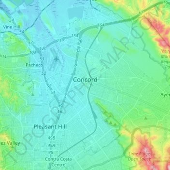
Name: Topografische Karte Concord, Höhe, Relief.
Ort: Concord, Contra Costa County, California, United States (37.92386 -122.06458 38.02272 -121.93283)
Durchschnittliche Höhe: 50 m
Minimale Höhe: -2 m
Maximale Höhe: 312 m
Spenden
Rüste dich für dein nächstes Abenteuer:
Als Amazon-Partner verdient diese Seite an qualifizierten Käufen, ohne dass Ihnen zusätzliche Kosten entstehen.
Andere topografische Karten
Klicken Sie auf eine Karte, um ihre Topografie, ihre Höhe und ihr Relief anzuzeigen.
Contra Costa Centre
United States > California > Contra Costa County
Contra Costa Centre is an unincorporated community and census-designated place in Contra Costa County, California. Contra Costa Centre sits at an elevation of 92 feet (28 m). The 2010 United States census reported Contra Costa Centre's population was 5,364, while the 2020 census figure was 6,808. Contra Costa…
Durchschnittliche Höhe: 36 m
Spenden
Rüste dich für dein nächstes Abenteuer:
Als Amazon-Partner verdient diese Seite an qualifizierten Käufen, ohne dass Ihnen zusätzliche Kosten entstehen.
Crolona Heights
United States > California > Contra Costa County > Crockett
Durchschnittliche Höhe: 61 m
Jewel Lake
United States > California > Contra Costa County > Kensington
Durchschnittliche Höhe: 221 m
Spenden
Rüste dich für dein nächstes Abenteuer:
Als Amazon-Partner verdient diese Seite an qualifizierten Käufen, ohne dass Ihnen zusätzliche Kosten entstehen.
Lafayette Reservoir
United States > California > Contra Costa County > Lafayette
Durchschnittliche Höhe: 174 m
Spenden
Rüste dich für dein nächstes Abenteuer:
Als Amazon-Partner verdient diese Seite an qualifizierten Käufen, ohne dass Ihnen zusätzliche Kosten entstehen.
Jewel Lake
United States > California > Contra Costa County > Kensington
Durchschnittliche Höhe: 221 m
Montalvin Park
United States > California > Contra Costa County > Rollingwood
Durchschnittliche Höhe: 52 m
Spenden
Rüste dich für dein nächstes Abenteuer:
Als Amazon-Partner verdient diese Seite an qualifizierten Käufen, ohne dass Ihnen zusätzliche Kosten entstehen.
Saranap
United States > California > Contra Costa County
Saranap (until 1913, Dewing Park) is a residential census-designated place (CDP) within central Contra Costa County, California. Lying at an elevation of 180 feet (55 m), it is bounded on the south and east by portions of Walnut Creek (including the gated senior residential development Rossmoor) and on the…
Durchschnittliche Höhe: 92 m
Cardiac Hill
United States > California > Contra Costa County > Pleasant Hill
Durchschnittliche Höhe: 31 m
Spenden
Rüste dich für dein nächstes Abenteuer:
Als Amazon-Partner verdient diese Seite an qualifizierten Käufen, ohne dass Ihnen zusätzliche Kosten entstehen.
North Richmond
United States > California > Contra Costa County > North Richmond
Durchschnittliche Höhe: 6 m
Spenden
Rüste dich für dein nächstes Abenteuer:
Als Amazon-Partner verdient diese Seite an qualifizierten Käufen, ohne dass Ihnen zusätzliche Kosten entstehen.
Discovery Bay
United States > California > Contra Costa County > Discovery Bay
Durchschnittliche Höhe: 0 m
Spenden
Rüste dich für dein nächstes Abenteuer:
Als Amazon-Partner verdient diese Seite an qualifizierten Käufen, ohne dass Ihnen zusätzliche Kosten entstehen.
Crolona Heights
United States > California > Contra Costa County > Crockett > Crolona Heights
Durchschnittliche Höhe: 61 m
Spenden
Rüste dich für dein nächstes Abenteuer:
Als Amazon-Partner verdient diese Seite an qualifizierten Käufen, ohne dass Ihnen zusätzliche Kosten entstehen.