
Topografische Karte Hillman
Interaktive Karte
Klicken Sie auf die Karte, um die Höhe anzuzeigen.
Über diese Karte
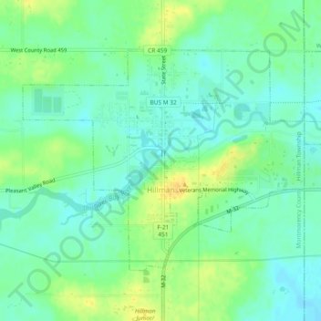
Name: Topografische Karte Hillman, Höhe, Relief.
Durchschnittliche Höhe: 234 m
Minimale Höhe: 224 m
Maximale Höhe: 250 m
Andere topografische Karten
Klicken Sie auf eine Karte, um ihre Topografie, ihre Höhe und ihr Relief anzuzeigen.
Atlanta
United States > Michigan > Montmorency County
Atlanta, Briley Township, Montmorency County, Michigan, United States
Durchschnittliche Höhe: 275 m
Montmorency Township
United States > Michigan > Montmorency County
Montmorency Township, Montmorency County, Michigan, 40709, United States
Durchschnittliche Höhe: 270 m
Hillman Township
United States > Michigan > Montmorency County
Hillman Township, Montmorency County, Michigan, 49746, United States
Durchschnittliche Höhe: 260 m
Lewiston
United States > Michigan > Montmorency County
Lewiston, Albert Township, Montmorency County, Michigan, 49756, United States
Durchschnittliche Höhe: 380 m