
Topografische Karte Lexington Hills
Interaktive Karte
Klicken Sie auf die Karte, um die Höhe anzuzeigen.
Über diese Karte
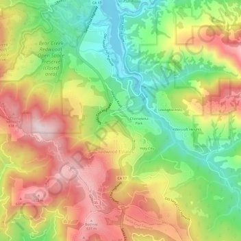
Name: Topografische Karte Lexington Hills, Höhe, Relief.
Durchschnittliche Höhe: 424 m
Minimale Höhe: 180 m
Maximale Höhe: 687 m
Andere topografische Karten
Klicken Sie auf eine Karte, um ihre Topografie, ihre Höhe und ihr Relief anzuzeigen.
Chemeketa Park
United States > California > Santa Clara County > Redwood Estates
Chemeketa Park, Redwood Estates, Santa Clara County, California, 95033, United States
Durchschnittliche Höhe: 413 m
Holy City
United States > California > Santa Clara County > Redwood Estates
Holy City, Redwood Estates, Santa Clara County, California, 95033, United States
Durchschnittliche Höhe: 429 m
Lexington Hills
United States > California > Santa Clara County > Redwood Estates > Lexington Hills
Lexington Hills, Redwood Estates, Santa Clara County, California, 95044, United States
Durchschnittliche Höhe: 406 m