
Spenden
Rüste dich für dein nächstes Abenteuer:
Als Amazon-Partner verdient diese Seite an qualifizierten Käufen, ohne dass Ihnen zusätzliche Kosten entstehen.
Topografische Karte Nanticoke
Klicken Sie auf die Karte, um die Höhe anzuzeigen.
Spenden
Rüste dich für dein nächstes Abenteuer:
Als Amazon-Partner verdient diese Seite an qualifizierten Käufen, ohne dass Ihnen zusätzliche Kosten entstehen.
Nanticoke
According to the United States Census Bureau, the city has a total area of 3.6 square miles (9.3 km2), of which 3.5 square miles (9.1 km2) is land and 0.1 square miles (0.26 km2), or 3.05%, is water. Nanticoke is located in the Wyoming Valley (near the Susquehanna River). The elevation is 696 feet (212 m). Both the Lower Broadway Street Bridge and the South Cross Valley Expressway cross over the Susquehanna River and connect Nanticoke with Plymouth Township. The topography of Nanticoke is hilly. The city can be divided into several sections: Honey Pot (northwestern Nanticoke), Downtown (northern and central Nanticoke), and Hanover Section (southeastern Nanticoke). Nanticoke Creek and Newport Creek run through the city.
Spenden
Rüste dich für dein nächstes Abenteuer:
Als Amazon-Partner verdient diese Seite an qualifizierten Käufen, ohne dass Ihnen zusätzliche Kosten entstehen.
Über diese Karte
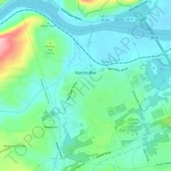
Name: Topografische Karte Nanticoke, Höhe, Relief.
Durchschnittliche Höhe: 192 m
Minimale Höhe: 152 m
Maximale Höhe: 327 m
Spenden
Rüste dich für dein nächstes Abenteuer:
Als Amazon-Partner verdient diese Seite an qualifizierten Käufen, ohne dass Ihnen zusätzliche Kosten entstehen.
Andere topografische Karten
Klicken Sie auf eine Karte, um ihre Topografie, ihre Höhe und ihr Relief anzuzeigen.
Ricketts Glen State Park
United States > Pennsylvania > Luzerne County > Fairmount Township
The state's original plans for the new park included building an inn, an 18-hole golf course and country club, and a winter sports complex for skiing, ice boating, and tobogganing, as well as a beach with bathing facilities, cabins, and a tent camping area. Only the last three were actually built, all south of…
Durchschnittliche Höhe: 588 m
Cambra
United States > Pennsylvania > Luzerne County > Huntington Township
Durchschnittliche Höhe: 311 m
Spenden
Rüste dich für dein nächstes Abenteuer:
Als Amazon-Partner verdient diese Seite an qualifizierten Käufen, ohne dass Ihnen zusätzliche Kosten entstehen.
Hobbie
United States > Pennsylvania > Luzerne County > Hollenback Township
Durchschnittliche Höhe: 302 m
Shavertown
United States > Pennsylvania > Luzerne County > Kingston Township
Durchschnittliche Höhe: 353 m
Wapwallopen
United States > Pennsylvania > Luzerne County > Conyngham Township
Durchschnittliche Höhe: 223 m
Spenden
Rüste dich für dein nächstes Abenteuer:
Als Amazon-Partner verdient diese Seite an qualifizierten Käufen, ohne dass Ihnen zusätzliche Kosten entstehen.
Town Hill
United States > Pennsylvania > Luzerne County > Huntington Township
Durchschnittliche Höhe: 281 m
Springtown
United States > Pennsylvania > Luzerne County > Dorrance Township
Durchschnittliche Höhe: 396 m
Roaring Brook
United States > Pennsylvania > Luzerne County > Hunlock Township
Durchschnittliche Höhe: 337 m
Langdon
United States > Pennsylvania > Luzerne County > Pittston Township
Durchschnittliche Höhe: 320 m
Spenden
Rüste dich für dein nächstes Abenteuer:
Als Amazon-Partner verdient diese Seite an qualifizierten Käufen, ohne dass Ihnen zusätzliche Kosten entstehen.
Fern Glen
United States > Pennsylvania > Luzerne County > Black Creek Township
Durchschnittliche Höhe: 391 m
Red Rock
United States > Pennsylvania > Luzerne County > Fairmount Township
Durchschnittliche Höhe: 438 m
Inkerman
United States > Pennsylvania > Luzerne County > Jenkins Township
Durchschnittliche Höhe: 215 m
Spenden
Rüste dich für dein nächstes Abenteuer:
Als Amazon-Partner verdient diese Seite an qualifizierten Käufen, ohne dass Ihnen zusätzliche Kosten entstehen.
Liewellyn Corners
United States > Pennsylvania > Luzerne County > Bear Creek Township
Durchschnittliche Höhe: 449 m
Plainsville
United States > Pennsylvania > Luzerne County > Plains Township
Durchschnittliche Höhe: 179 m
Suscon
United States > Pennsylvania > Luzerne County > Pittston Township
Durchschnittliche Höhe: 401 m
Spenden
Rüste dich für dein nächstes Abenteuer:
Als Amazon-Partner verdient diese Seite an qualifizierten Käufen, ohne dass Ihnen zusätzliche Kosten entstehen.
Hazleton Station
United States > Pennsylvania > Luzerne County > Hazleton
Durchschnittliche Höhe: 516 m
Hilldale
United States > Pennsylvania > Luzerne County > Plains Township
Durchschnittliche Höhe: 192 m
Spenden
Rüste dich für dein nächstes Abenteuer:
Als Amazon-Partner verdient diese Seite an qualifizierten Käufen, ohne dass Ihnen zusätzliche Kosten entstehen.
Sweet Valley
United States > Pennsylvania > Luzerne County > Ross Township
Durchschnittliche Höhe: 390 m
Wapwallopen
United States > Pennsylvania > Luzerne County > Conyngham Township
Durchschnittliche Höhe: 223 m
Glen Summit
United States > Pennsylvania > Luzerne County > Fairview Township
Durchschnittliche Höhe: 539 m
Spenden
Rüste dich für dein nächstes Abenteuer:
Als Amazon-Partner verdient diese Seite an qualifizierten Käufen, ohne dass Ihnen zusätzliche Kosten entstehen.
Hunlock Creek
United States > Pennsylvania > Luzerne County > Hunlock Township > Hunlock
Durchschnittliche Höhe: 276 m
Shavertown
United States > Pennsylvania > Luzerne County > Kingston Township
Durchschnittliche Höhe: 353 m
Huntington Mills
United States > Pennsylvania > Luzerne County > Huntington Township
Durchschnittliche Höhe: 289 m
Spenden
Rüste dich für dein nächstes Abenteuer:
Als Amazon-Partner verdient diese Seite an qualifizierten Käufen, ohne dass Ihnen zusätzliche Kosten entstehen.
Hillside
United States > Pennsylvania > Luzerne County > Kingston Township
Durchschnittliche Höhe: 342 m
Lindbergh
United States > Pennsylvania > Luzerne County > Wright Township
Durchschnittliche Höhe: 386 m
Hilldale
United States > Pennsylvania > Luzerne County > Plains Township
Durchschnittliche Höhe: 192 m
Spenden
Rüste dich für dein nächstes Abenteuer:
Als Amazon-Partner verdient diese Seite an qualifizierten Käufen, ohne dass Ihnen zusätzliche Kosten entstehen.
Fern Glen
United States > Pennsylvania > Luzerne County > Black Creek Township
Durchschnittliche Höhe: 391 m
South Pond Dam
United States > Pennsylvania > Luzerne County > Hanover Township
Durchschnittliche Höhe: 204 m
Cambra
United States > Pennsylvania > Luzerne County > Huntington Township
Durchschnittliche Höhe: 311 m
Spenden
Rüste dich für dein nächstes Abenteuer:
Als Amazon-Partner verdient diese Seite an qualifizierten Käufen, ohne dass Ihnen zusätzliche Kosten entstehen.