Geolokalisieren

Topografische Karte Aledo

Interaktive Karte

Klicken Sie auf die Karte, um die Höhe anzuzeigen.

Über diese Karte

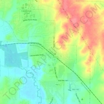
Name: Topografische Karte Aledo, Höhe, Relief.

Ort: Aledo, Parker County, Texas, United States (32.67678 -97.62642 32.71900 -97.58975)

Durchschnittliche Höhe: 271 m

Minimale Höhe: 238 m

Maximale Höhe: 317 m

Andere topografische Karten

Klicken Sie auf eine Karte, um ihre Topografie, ihre Höhe und ihr Relief anzuzeigen.

Dennis

United States > Texas > Parker County

Dennis, Parker County, Texas, United States

Durchschnittliche Höhe: 233 m

Agnes

United States > Texas > Parker County

Agnes, Parker County, Texas, 76482, United States

Durchschnittliche Höhe: 351 m

Garner

United States > Texas > Parker County

Garner, Parker County, Texas, United States

Durchschnittliche Höhe: 296 m

Weatherford

United States > Texas > Parker County

Weatherford, Parker County, Texas, 76086, United States

Durchschnittliche Höhe: 326 m

Lake Weatherford

United States > Texas > Parker County > Weatherford

Lake Weatherford, Weatherford, Parker County, Texas, United States

Durchschnittliche Höhe: 289 m

Reno

United States > Texas > Parker County > Reno > Reno

Reno, Parker County, Texas, United States

Durchschnittliche Höhe: 226 m