
Topografische Karte Magal
Interaktive Karte
Klicken Sie auf die Karte, um die Höhe anzuzeigen.
Über diese Karte
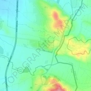
Name: Topografische Karte Magal, Höhe, Relief.
Durchschnittliche Höhe: 65 m
Minimale Höhe: 31 m
Maximale Höhe: 150 m
Kibbutz Magal was founded in 1953 as a Nahal settlement on a hill overlooking the Samaria hills and what was then the border with Jordan. The kibbutz sits on a hill known from the War of Independence as the "86th Regiment"—on any elevation of the hill above the sea level (86 meters). The kibbutz was founded by the Tzofim battalion, but when they left, Nahal members began to settle there, which continued to reach it until the 1980s.
Andere topografische Karten
Klicken Sie auf eine Karte, um ihre Topografie, ihre Höhe und ihr Relief anzuzeigen.
Regavim
Israel > Haifa District > Menashe Regional Council
Regavim, Menashe Regional Council, Hadera Subdistrict, Haifa District, Israel
Durchschnittliche Höhe: 105 m
Barkai
Israel > Haifa District > Menashe Regional Council
Barkai, Menashe Regional Council, Hadera Subdistrict, Haifa District, Israel
Durchschnittliche Höhe: 74 m