
Topografische Karte Biłgoraj
Interaktive Karte
Klicken Sie auf die Karte, um die Höhe anzuzeigen.
Über diese Karte
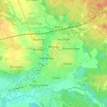
Name: Topografische Karte Biłgoraj, Höhe, Relief.
Ort: Biłgoraj, Biłgoraj County, Lublin Voivodeship, 23-400, Poland (50.51312 22.67465 50.56491 22.74874)
Durchschnittliche Höhe: 199 m
Minimale Höhe: 182 m
Maximale Höhe: 219 m
Biłgoraj lies in northern part of Sandomierz Basin, near Roztocze. The town is surrounded by Solska Forest, 20 km (12 mi) from Roztocze National Park. An average July temperature in Biłgoraj is 18 °C (64 °F), an average January temperature −2.8 °C (27.0 °F). The town is crossed by four small rivers: Biała Łada, Czarna Łada, Osa and Próchnica. Biłgoraj lies on the elevations ranging from 184 to 212 meters above sea level. The area of the town is 20 square kilometres (8 square miles), of which forests covers 9%. Built-up area stretches along eastern bank of the Biała Łada, for 5 km (3 mi) (north–south) and 3 km (2 mi) (west–east).