
Spenden
Rüste dich für dein nächstes Abenteuer:
Als Amazon-Partner verdient diese Seite an qualifizierten Käufen, ohne dass Ihnen zusätzliche Kosten entstehen.
Topografische Karte Sesquicentennial State Park
Klicken Sie auf die Karte, um die Höhe anzuzeigen.
Spenden
Rüste dich für dein nächstes Abenteuer:
Als Amazon-Partner verdient diese Seite an qualifizierten Käufen, ohne dass Ihnen zusätzliche Kosten entstehen.
Sesquicentennial State Park
This park offers three picnic shelters, four picnic pads, and 84 campsites that vary in amenities & sizes. The park provides rental fishing boats, paddle boats, standup paddleboards, kayaks, canoes, fishing access to the 30-acre (12 ha) park lake, and four trails providing over 12 miles (19 km) of recreational access. The Sandhills Trail is an ADA-accessible two-mile (3.2 km) loop around the park lake. The Bike Trail is 6.5 miles (10.5 km) of moderate sandy terrain with several changes in elevation. Sesqui is the only South Carolina State Park that offers a full-scale splash pad and a membership-only dog park that allows dogs to run off-leash. The park office sells firewood, ice, t-shirts, and novelty Gifts.
Spenden
Rüste dich für dein nächstes Abenteuer:
Als Amazon-Partner verdient diese Seite an qualifizierten Käufen, ohne dass Ihnen zusätzliche Kosten entstehen.
Über diese Karte
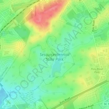
Name: Topografische Karte Sesquicentennial State Park, Höhe, Relief.
Durchschnittliche Höhe: 97 m
Minimale Höhe: 67 m
Maximale Höhe: 141 m
Spenden
Rüste dich für dein nächstes Abenteuer:
Als Amazon-Partner verdient diese Seite an qualifizierten Käufen, ohne dass Ihnen zusätzliche Kosten entstehen.
Andere topografische Karten
Klicken Sie auf eine Karte, um ihre Topografie, ihre Höhe und ihr Relief anzuzeigen.
Columbia
United States > South Carolina > Richland County
Columbia features a relatively gentle and rolling topography. The elevation in this area varies, with the city itself situated around 318 feet above sea level, while the surrounding regions exhibit elevations that can reach as high as 573 feet. The landscape is characterized by a mix of low-lying areas and…
Durchschnittliche Höhe: 89 m
Brandon Hills
United States > South Carolina > Richland County > Columbia
Durchschnittliche Höhe: 62 m
Forest I At Harbison
United States > South Carolina > Richland County > Columbia
Durchschnittliche Höhe: 87 m
Spenden
Rüste dich für dein nächstes Abenteuer:
Als Amazon-Partner verdient diese Seite an qualifizierten Käufen, ohne dass Ihnen zusätzliche Kosten entstehen.
Spenden
Rüste dich für dein nächstes Abenteuer:
Als Amazon-Partner verdient diese Seite an qualifizierten Käufen, ohne dass Ihnen zusätzliche Kosten entstehen.
Columbia
United States > South Carolina > Richland County
The city has capitalized on this location, which includes three rivers, by identifying as "The Columbia Riverbanks Region". Columbia is located roughly halfway between the Atlantic Ocean and the Blue Ridge Mountains, at an elevation around 292 ft (89 m).
Durchschnittliche Höhe: 89 m
Spenden
Rüste dich für dein nächstes Abenteuer:
Als Amazon-Partner verdient diese Seite an qualifizierten Käufen, ohne dass Ihnen zusätzliche Kosten entstehen.
Saint Andrews
United States > South Carolina > Richland County > Columbia
Durchschnittliche Höhe: 77 m
Columbia
United States > South Carolina > Richland County
The city has capitalized on this location, which includes three rivers, by identifying as "The Columbia Riverbanks Region". Columbia is located roughly halfway between the Atlantic Ocean and the Blue Ridge Mountains, at an elevation around 292 ft (89 m).
Durchschnittliche Höhe: 89 m
Spenden
Rüste dich für dein nächstes Abenteuer:
Als Amazon-Partner verdient diese Seite an qualifizierten Käufen, ohne dass Ihnen zusätzliche Kosten entstehen.
Hampton Trace
United States > South Carolina > Richland County > Columbia
Durchschnittliche Höhe: 59 m
Columbia
United States > South Carolina > Richland County
The city has capitalized on this location, which includes three rivers, by identifying as "The Columbia Riverbanks Region". Columbia is located roughly halfway between the Atlantic Ocean and the Blue Ridge Mountains, at an elevation around 292 ft (89 m).
Durchschnittliche Höhe: 89 m
Spenden
Rüste dich für dein nächstes Abenteuer:
Als Amazon-Partner verdient diese Seite an qualifizierten Käufen, ohne dass Ihnen zusätzliche Kosten entstehen.
Forest I At Harbison
United States > South Carolina > Richland County > Columbia
Durchschnittliche Höhe: 87 m
Riverbanks
United States > South Carolina > Richland County > Columbia > Riverbanks
Durchschnittliche Höhe: 69 m
Lincolnshire
United States > South Carolina > Richland County > Lincolnshire
Durchschnittliche Höhe: 80 m
Spenden
Rüste dich für dein nächstes Abenteuer:
Als Amazon-Partner verdient diese Seite an qualifizierten Käufen, ohne dass Ihnen zusätzliche Kosten entstehen.