
Spenden
Rüste dich für dein nächstes Abenteuer:
Als Amazon-Partner verdient diese Seite an qualifizierten Käufen, ohne dass Ihnen zusätzliche Kosten entstehen.
Topografische Karte Boulder Creek
Klicken Sie auf die Karte, um die Höhe anzuzeigen.
Spenden
Rüste dich für dein nächstes Abenteuer:
Als Amazon-Partner verdient diese Seite an qualifizierten Käufen, ohne dass Ihnen zusätzliche Kosten entstehen.
Boulder Creek
Boulder Creek sits at the north end of the San Lorenzo Valley at the confluence of San Lorenzo River and Boulder Creek within the Santa Cruz Mountains, a Level IV ecoregion designated by the United States Environmental Protection Agency (EPA), an area surrounded by steep, redwood- and pine- covered hills formed by the river, creek, and their tributaries. The river flows through Boulder Creek on the east and south through Brookdale, Ben Lomond, and Felton, and continues south to the City of Santa Cruz where it enters Monterey Bay. Directly across from Boulder Creek's confluence with the San Lorenzo River, Bear Creek flows into the river and creates a topographical feature known as the Turkey Foot. The Turkey Foot creates a floodplain, particularly on the western side of the river where the mountainside is less steep.
Spenden
Rüste dich für dein nächstes Abenteuer:
Als Amazon-Partner verdient diese Seite an qualifizierten Käufen, ohne dass Ihnen zusätzliche Kosten entstehen.
Über diese Karte
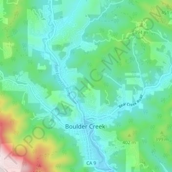
Name: Topografische Karte Boulder Creek, Höhe, Relief.
Durchschnittliche Höhe: 287 m
Minimale Höhe: 136 m
Maximale Höhe: 799 m
Spenden
Rüste dich für dein nächstes Abenteuer:
Als Amazon-Partner verdient diese Seite an qualifizierten Käufen, ohne dass Ihnen zusätzliche Kosten entstehen.
Andere topografische Karten
Klicken Sie auf eine Karte, um ihre Topografie, ihre Höhe und ihr Relief anzuzeigen.
Spenden
Rüste dich für dein nächstes Abenteuer:
Als Amazon-Partner verdient diese Seite an qualifizierten Käufen, ohne dass Ihnen zusätzliche Kosten entstehen.
Live Oak
United States > California > Santa Cruz County > Live Oak
Live Oak is a census-designated place (CDP) in Santa Cruz County, California between the cities of Santa Cruz and Capitola and north of the former Union Pacific railroad. Live Oak sits at an elevation of 102 feet (31 m). The population was 17,038 at the 2020 census. The population of the greater Live Oak area,…
Durchschnittliche Höhe: 47 m
Shangri La Estates
United States > California > Santa Cruz County > Pleasure Point
Durchschnittliche Höhe: 12 m
Spenden
Rüste dich für dein nächstes Abenteuer:
Als Amazon-Partner verdient diese Seite an qualifizierten Käufen, ohne dass Ihnen zusätzliche Kosten entstehen.
Spenden
Rüste dich für dein nächstes Abenteuer:
Als Amazon-Partner verdient diese Seite an qualifizierten Käufen, ohne dass Ihnen zusätzliche Kosten entstehen.
Spenden
Rüste dich für dein nächstes Abenteuer:
Als Amazon-Partner verdient diese Seite an qualifizierten Käufen, ohne dass Ihnen zusätzliche Kosten entstehen.
Spenden
Rüste dich für dein nächstes Abenteuer:
Als Amazon-Partner verdient diese Seite an qualifizierten Käufen, ohne dass Ihnen zusätzliche Kosten entstehen.
Yacht Harbor Manor
United States > California > Santa Cruz County > Live Oak
Durchschnittliche Höhe: 19 m
Australian Garden
United States > California > Santa Cruz County > Santa Cruz
Durchschnittliche Höhe: 131 m
Spenden
Rüste dich für dein nächstes Abenteuer:
Als Amazon-Partner verdient diese Seite an qualifizierten Käufen, ohne dass Ihnen zusätzliche Kosten entstehen.
Huckleberry Woods
United States > California > Santa Cruz County > Boulder Creek
Durchschnittliche Höhe: 263 m
Spenden
Rüste dich für dein nächstes Abenteuer:
Als Amazon-Partner verdient diese Seite an qualifizierten Käufen, ohne dass Ihnen zusätzliche Kosten entstehen.
Lomond Terrace
United States > California > Santa Cruz County > Ben Lomond
Durchschnittliche Höhe: 231 m
Spenden
Rüste dich für dein nächstes Abenteuer:
Als Amazon-Partner verdient diese Seite an qualifizierten Käufen, ohne dass Ihnen zusätzliche Kosten entstehen.