
Topografische Karte Southwell CP
Interaktive Karte
Klicken Sie auf die Karte, um die Höhe anzuzeigen.
Über diese Karte
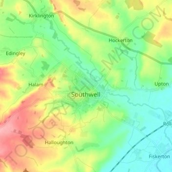
Name: Topografische Karte Southwell CP, Höhe, Relief.
Durchschnittliche Höhe: 47 m
Minimale Höhe: 12 m
Maximale Höhe: 108 m
Andere topografische Karten
Klicken Sie auf eine Karte, um ihre Topografie, ihre Höhe und ihr Relief anzuzeigen.
Staythorpe CP
United Kingdom > England > Nottinghamshire > Newark and Sherwood
Staythorpe CP, Newark and Sherwood, Nottinghamshire, England, United Kingdom
Durchschnittliche Höhe: 16 m
Newark on Trent
United Kingdom > England > Nottinghamshire > Newark and Sherwood
Newark on Trent, Newark and Sherwood, Nottinghamshire, England, NG24 1EJ, United Kingdom
Durchschnittliche Höhe: 18 m
Sherwood Forest NNR
United Kingdom > England > Nottinghamshire > Newark and Sherwood > Ollerton
Sherwood Forest NNR, Ollerton, Newark and Sherwood, Nottinghamshire, England, NG21 9HN, United Kingdom
Durchschnittliche Höhe: 71 m
Goverton
United Kingdom > England > Nottinghamshire > Newark and Sherwood > Bleasby
Goverton, Bleasby, Newark and Sherwood, Nottinghamshire, England, NG14 7FN, United Kingdom
Durchschnittliche Höhe: 33 m