
Topografische Karte Manhattan Island
Interaktive Karte
Klicken Sie auf die Karte, um die Höhe anzuzeigen.
Über diese Karte
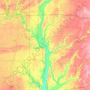
Name: Topografische Karte Manhattan Island, Höhe, Relief.
Durchschnittliche Höhe: 201 m
Minimale Höhe: 137 m
Maximale Höhe: 266 m
Andere topografische Karten
Klicken Sie auf eine Karte, um ihre Topografie, ihre Höhe und ihr Relief anzuzeigen.
Brendonwood
United States of America > Indiana > Indianapolis > Brendonwood
Brendonwood, Indianapolis, Marion, Indiana, 46226, United States of America
Durchschnittliche Höhe: 248 m
Glenns Valley
United States of America > Indiana > Indianapolis > Glenns Valley
Glenns Valley, Indianapolis, Marion, Indiana, 46217, United States of America
Durchschnittliche Höhe: 211 m
Fiskville
United States of America > Indiana > Fiskville
Fiskville, Montgomery County, Indiana, 47933, United States of America
Durchschnittliche Höhe: 230 m
Rob Roy
United States of America > Indiana > Rob Roy
Rob Roy, Fountain County, Indiana, United States of America
Durchschnittliche Höhe: 197 m
Chandler
United States of America > Indiana > Chandler
Chandler, Pike County, Indiana, United States of America
Durchschnittliche Höhe: 151 m
Blackford County
United States of America > Indiana
Blackford County, Indiana, United States of America
Durchschnittliche Höhe: 274 m
Linville
United States of America > Indiana > Linville
Linville, Shelby County, Indiana, 46144, United States of America
Durchschnittliche Höhe: 272 m
Kokomo
United States of America > Indiana > Kokomo
Kokomo, Howard County, Indiana, 46903, United States of America
Durchschnittliche Höhe: 252 m
Mount Wells
United States of America > Indiana > Beverly Shores
Mount Wells, Beverly Shores, Porter County, Indiana, 46301, United States of America
Durchschnittliche Höhe: 182 m