
Topografische Karte Plano
Klicken Sie auf die Karte, um die Höhe anzuzeigen.
Plano
At first, Plano's population grew slowly, reaching 1,304 in 1900 and 3,695 in 1960. By 1970, Plano began to feel some of the boom its neighbors had experienced after World War II. A series of public works projects and a change in taxes that removed the farming community from the town helped increase the population. In 1970, the population reached 17,872, and by 1980, it had exploded to 72,000. Sewers, schools, and street development kept pace with this massive increase, largely because of Plano's flat topography, grid layout, and planning initiatives.
Über diese Karte
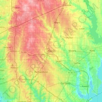
Name: Topografische Karte Plano, Höhe, Relief.
Ort: Plano, Collin County, Texas, 75074, United States (32.85368 -96.85251 33.17368 -96.53251)
Durchschnittliche Höhe: 181 m
Minimale Höhe: 131 m
Maximale Höhe: 244 m
Andere topografische Karten
Klicken Sie auf eine Karte, um ihre Topografie, ihre Höhe und ihr Relief anzuzeigen.