
Spenden
Rüste dich für dein nächstes Abenteuer:
Als Amazon-Partner verdient diese Seite an qualifizierten Käufen, ohne dass Ihnen zusätzliche Kosten entstehen.
Topografische Karte Hammond
Klicken Sie auf die Karte, um die Höhe anzuzeigen.
Spenden
Rüste dich für dein nächstes Abenteuer:
Als Amazon-Partner verdient diese Seite an qualifizierten Käufen, ohne dass Ihnen zusätzliche Kosten entstehen.
Über diese Karte
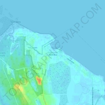
Name: Topografische Karte Hammond, Höhe, Relief.
Durchschnittliche Höhe: 3 m
Minimale Höhe: -3 m
Maximale Höhe: 34 m
Spenden
Rüste dich für dein nächstes Abenteuer:
Als Amazon-Partner verdient diese Seite an qualifizierten Käufen, ohne dass Ihnen zusätzliche Kosten entstehen.
Andere topografische Karten
Klicken Sie auf eine Karte, um ihre Topografie, ihre Höhe und ihr Relief anzuzeigen.
Cannon Beach
United States > Oregon > Clatsop County
Cannon Beach is recognized by the well-known landmark Haystack Rock, located southwest of downtown Cannon Beach. This sea stack has an elevation of 235 feet (72 m) and is often accessible at low tide, especially in the summertime. There is a small cave system that penetrates its igneous rock that can be seen…
Durchschnittliche Höhe: 42 m
Spenden
Rüste dich für dein nächstes Abenteuer:
Als Amazon-Partner verdient diese Seite an qualifizierten Käufen, ohne dass Ihnen zusätzliche Kosten entstehen.
Cannon Beach
United States > Oregon > Clatsop County
Cannon Beach is recognized by the well-known landmark Haystack Rock, located southwest of downtown Cannon Beach. This sea stack has an elevation of 235 feet (72 m) and is often accessible at low tide, especially in the summertime. There is a small cave system that penetrates its igneous rock that can be seen…
Durchschnittliche Höhe: 42 m