
Spenden
Rüste dich für dein nächstes Abenteuer:
Als Amazon-Partner verdient diese Seite an qualifizierten Käufen, ohne dass Ihnen zusätzliche Kosten entstehen.
Topografische Karte Harwinton
Klicken Sie auf die Karte, um die Höhe anzuzeigen.
Spenden
Rüste dich für dein nächstes Abenteuer:
Als Amazon-Partner verdient diese Seite an qualifizierten Käufen, ohne dass Ihnen zusätzliche Kosten entstehen.
Über diese Karte
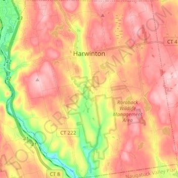
Name: Topografische Karte Harwinton, Höhe, Relief.
Durchschnittliche Höhe: 252 m
Minimale Höhe: 117 m
Maximale Höhe: 341 m
Spenden
Rüste dich für dein nächstes Abenteuer:
Als Amazon-Partner verdient diese Seite an qualifizierten Käufen, ohne dass Ihnen zusätzliche Kosten entstehen.
Andere topografische Karten
Klicken Sie auf eine Karte, um ihre Topografie, ihre Höhe und ihr Relief anzuzeigen.
Apple Hill
United States > Connecticut > Northwest Hills Planning Region > Morris
Durchschnittliche Höhe: 297 m
Northfield
United States > Connecticut > Northwest Hills Planning Region > Litchfield
Durchschnittliche Höhe: 259 m
Bakerville
United States > Connecticut > Northwest Hills Planning Region > New Hartford
Durchschnittliche Höhe: 244 m
Haystack Mountain
United States > Connecticut > Northwest Hills Planning Region > Norfolk
Durchschnittliche Höhe: 385 m
Spenden
Rüste dich für dein nächstes Abenteuer:
Als Amazon-Partner verdient diese Seite an qualifizierten Käufen, ohne dass Ihnen zusätzliche Kosten entstehen.
Marble Dale
United States > Connecticut > Northwest Hills Planning Region > Washington
Durchschnittliche Höhe: 249 m
Washington Depot
United States > Connecticut > Northwest Hills Planning Region > Washington
Durchschnittliche Höhe: 231 m
Nelsons Corner
United States > Connecticut > Northwest Hills Planning Region > Winchester
Durchschnittliche Höhe: 275 m
Nepaug
United States > Connecticut > Northwest Hills Planning Region > New Hartford
Durchschnittliche Höhe: 222 m
Spenden
Rüste dich für dein nächstes Abenteuer:
Als Amazon-Partner verdient diese Seite an qualifizierten Käufen, ohne dass Ihnen zusätzliche Kosten entstehen.
West Torrington
United States > Connecticut > Northwest Hills Planning Region > Torrington
Durchschnittliche Höhe: 270 m
Lakeville
United States > Connecticut > Northwest Hills Planning Region > Salisbury
Durchschnittliche Höhe: 259 m
West Cornwall
United States > Connecticut > Northwest Hills Planning Region
Durchschnittliche Höhe: 288 m
East Morris
United States > Connecticut > Northwest Hills Planning Region > Morris
Durchschnittliche Höhe: 294 m
Spenden
Rüste dich für dein nächstes Abenteuer:
Als Amazon-Partner verdient diese Seite an qualifizierten Käufen, ohne dass Ihnen zusätzliche Kosten entstehen.
Wangum Village
United States > Connecticut > Northwest Hills Planning Region > Canaan
Durchschnittliche Höhe: 235 m
Pleasant Valley
United States > Connecticut > Northwest Hills Planning Region > Barkhamsted
Durchschnittliche Höhe: 192 m
Drakeville
United States > Connecticut > Northwest Hills Planning Region > Torrington
Durchschnittliche Höhe: 309 m
Lookout
United States > Connecticut > Northwest Hills Planning Region > Goshen
Durchschnittliche Höhe: 434 m
Spenden
Rüste dich für dein nächstes Abenteuer:
Als Amazon-Partner verdient diese Seite an qualifizierten Käufen, ohne dass Ihnen zusätzliche Kosten entstehen.
Bartholomew Hill
United States > Connecticut > Northwest Hills Planning Region > Goshen
Durchschnittliche Höhe: 426 m
Canaan Valley
United States > Connecticut > Northwest Hills Planning Region > North Canaan
Durchschnittliche Höhe: 293 m
Bear Mountain
United States > Connecticut > Northwest Hills Planning Region > Salisbury
Bear Mountain is a peak of the southern Taconic Mountains in Salisbury, Connecticut. At 2,316 feet (706 m) (note, per references 1 and 3, there is disagreement about the precise elevation), Bear Mountain is the highest mountain that lies wholly within Connecticut. However, it is not the state highpoint: in the…
Durchschnittliche Höhe: 544 m
The Matterhorn
United States > Connecticut > Northwest Hills Planning Region > Canaan
Durchschnittliche Höhe: 462 m
Spenden
Rüste dich für dein nächstes Abenteuer:
Als Amazon-Partner verdient diese Seite an qualifizierten Käufen, ohne dass Ihnen zusätzliche Kosten entstehen.
Bear Mountain
United States > Connecticut > Northwest Hills Planning Region > Salisbury
Bear Mountain is a peak of the southern Taconic Mountains in Salisbury, Connecticut. At 2,316 feet (706 m) (note, per references 1 and 3, there is disagreement about the precise elevation), Bear Mountain is the highest mountain that lies wholly within Connecticut. However, it is not the state highpoint: in the…
Durchschnittliche Höhe: 544 m
The Matterhorn
United States > Connecticut > Northwest Hills Planning Region > Canaan
Durchschnittliche Höhe: 462 m
Lime Rock
United States > Connecticut > Northwest Hills Planning Region > Salisbury
Durchschnittliche Höhe: 238 m
Northfield
United States > Connecticut > Northwest Hills Planning Region > Litchfield
Durchschnittliche Höhe: 259 m
Spenden
Rüste dich für dein nächstes Abenteuer:
Als Amazon-Partner verdient diese Seite an qualifizierten Käufen, ohne dass Ihnen zusätzliche Kosten entstehen.
Bradford Mountain
United States > Connecticut > Northwest Hills Planning Region > Canaan
Durchschnittliche Höhe: 470 m
Bulls Bridge
United States > Connecticut > Northwest Hills Planning Region > Kent
Durchschnittliche Höhe: 178 m
Panorama Hill
United States > Connecticut > Northwest Hills Planning Region > Colebrook
Durchschnittliche Höhe: 379 m
Bear Mountain
United States > Connecticut > Northwest Hills Planning Region > Salisbury
Bear Mountain is a peak of the southern Taconic Mountains in Salisbury, Connecticut. At 2,316 feet (706 m) (note, per references 1 and 3, there is disagreement about the precise elevation), Bear Mountain is the highest mountain that lies wholly within Connecticut. However, it is not the state highpoint: in the…
Durchschnittliche Höhe: 544 m
Spenden
Rüste dich für dein nächstes Abenteuer:
Als Amazon-Partner verdient diese Seite an qualifizierten Käufen, ohne dass Ihnen zusätzliche Kosten entstehen.
Town Hill
United States > Connecticut > Northwest Hills Planning Region > New Hartford
Durchschnittliche Höhe: 255 m
Torringford
United States > Connecticut > Northwest Hills Planning Region > Torrington
Durchschnittliche Höhe: 301 m
Bear Mountain
United States > Connecticut > Northwest Hills Planning Region > Salisbury
Bear Mountain is a peak of the southern Taconic Mountains in Salisbury, Connecticut. At 2,316 feet (706 m) (note, per references 1 and 3, there is disagreement about the precise elevation), Bear Mountain is the highest mountain that lies wholly within Connecticut. However, it is not the state highpoint: in the…
Durchschnittliche Höhe: 544 m
Northfield
United States > Connecticut > Northwest Hills Planning Region > Litchfield
Durchschnittliche Höhe: 259 m
Spenden
Rüste dich für dein nächstes Abenteuer:
Als Amazon-Partner verdient diese Seite an qualifizierten Käufen, ohne dass Ihnen zusätzliche Kosten entstehen.
Grand Staircase
United States > Connecticut > Northwest Hills Planning Region > Kent
Durchschnittliche Höhe: 205 m
Milton Hill
United States > Connecticut > Northwest Hills Planning Region > Goshen
Durchschnittliche Höhe: 368 m
Apple Hill
United States > Connecticut > Northwest Hills Planning Region > Morris
Durchschnittliche Höhe: 297 m
Canaan Valley
United States > Connecticut > Northwest Hills Planning Region > North Canaan
Durchschnittliche Höhe: 293 m
Spenden
Rüste dich für dein nächstes Abenteuer:
Als Amazon-Partner verdient diese Seite an qualifizierten Käufen, ohne dass Ihnen zusätzliche Kosten entstehen.
West Cornwall
United States > Connecticut > Northwest Hills Planning Region
Durchschnittliche Höhe: 288 m
Burrville
United States > Connecticut > Northwest Hills Planning Region > Torrington
Durchschnittliche Höhe: 292 m