
Topografische Karte Tinian Island
Interaktive Karte
Klicken Sie auf die Karte, um die Höhe anzuzeigen.
Über diese Karte
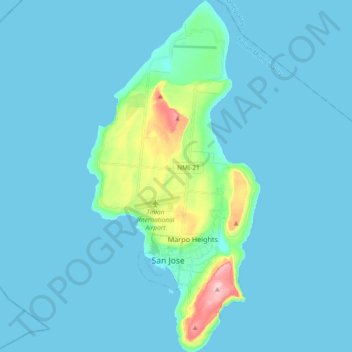
Name: Topografische Karte Tinian Island, Höhe, Relief.
Durchschnittliche Höhe: 17 m
Minimale Höhe: 0 m
Maximale Höhe: 187 m
Tinian is about 5 nautical miles (9.3 km) southwest of Saipan, from which it is separated by the Saipan Channel. It has a land area of 39 square miles (100 km2), with its highest elevation at Mount Lasso at 171 meters (561 ft).