
Topografische Karte Durham
Interaktive Karte
Klicken Sie auf die Karte, um die Höhe anzuzeigen.
Über diese Karte
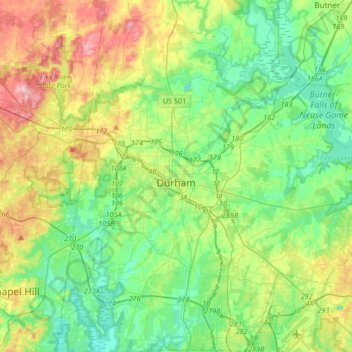
Name: Topografische Karte Durham, Höhe, Relief.
Ort: Durham, Durham County, North Carolina, United States (35.86635 -79.00750 36.13701 -78.75691)
Durchschnittliche Höhe: 117 m
Minimale Höhe: 61 m
Maximale Höhe: 238 m
Durham is located in the east-central part of the Piedmont region at 35°59′19″N 78°54′26″W / 35.98861°N 78.90722°W / 35.98861; -78.90722 (35.988644, −78.907167). Like much of the region, its topography is generally flat with some rolling hills.
Andere topografische Karten
Klicken Sie auf eine Karte, um ihre Topografie, ihre Höhe und ihr Relief anzuzeigen.
Glen Forest
United States > North Carolina > Durham County
Glen Forest, Durham County, North Carolina, United States
Durchschnittliche Höhe: 101 m
Durham
United States > North Carolina > Durham County > Durham
Durham, Durham County, North Carolina, 27701, United States
Durchschnittliche Höhe: 119 m