Geolokalisieren

Topografische Karte Beetley

Klicken Sie auf die Karte, um die Höhe anzuzeigen.

👉 Easily get elevation data in JSON, GeoTIFF and KML formats using Elevation API
Vielen Dank für die Unterstützung dieser Website ❤️
Spenden

Über diese Karte

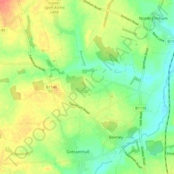
Name: Topografische Karte Beetley, Höhe, Relief.

Ort: Beetley, Breckland District, Norfolk, England, United Kingdom (52.71373 0.86905 52.74811 0.94809)

Durchschnittliche Höhe: 46 m

Minimale Höhe: 23 m

Maximale Höhe: 75 m

Andere topografische Karten

Klicken Sie auf eine Karte, um ihre Topografie, ihre Höhe und ihr Relief anzuzeigen.

Wendling Beck

United Kingdom > England > Norfolk > Breckland District

Durchschnittliche Höhe: 49 m

East Harling

United Kingdom > England > Norfolk > Breckland District

Durchschnittliche Höhe: 29 m

Saham Toney

United Kingdom > England > Norfolk > Breckland District

Durchschnittliche Höhe: 52 m

Illington

United Kingdom > England > Norfolk > Breckland District

Durchschnittliche Höhe: 35 m

East Harling

United Kingdom > England > Norfolk > Breckland District

Durchschnittliche Höhe: 29 m

Little Fransham

United Kingdom > England > Norfolk > Breckland District

Durchschnittliche Höhe: 73 m

Saham Hills

United Kingdom > England > Norfolk > Breckland District > Saham Toney

Durchschnittliche Höhe: 61 m

Daffy Green

United Kingdom > England > Norfolk > Breckland District

Durchschnittliche Höhe: 71 m

Drymere

United Kingdom > England > Norfolk > Breckland District

Durchschnittliche Höhe: 36 m

Reymerston

United Kingdom > England > Norfolk > Breckland District

Durchschnittliche Höhe: 47 m

Lower Stow Bedon

United Kingdom > England > Norfolk > Breckland District

Durchschnittliche Höhe: 41 m

Thuxton

United Kingdom > England > Norfolk > Breckland District

Durchschnittliche Höhe: 46 m

Sporle

United Kingdom > England > Norfolk > Breckland District

Durchschnittliche Höhe: 72 m

Eccles

United Kingdom > England > Norfolk > Breckland District

Durchschnittliche Höhe: 35 m

Ling Plantation

United Kingdom > England > Norfolk > Breckland District

Durchschnittliche Höhe: 49 m

Billingford

United Kingdom > England > Norfolk > Breckland District

Durchschnittliche Höhe: 38 m

Wilby

United Kingdom > England > Norfolk > Breckland District

Durchschnittliche Höhe: 36 m

Roudham

United Kingdom > England > Norfolk > Breckland District > Bridgham

Durchschnittliche Höhe: 31 m

Garvestone

United Kingdom > England > Norfolk > Breckland District

Durchschnittliche Höhe: 49 m

Stonebridge

United Kingdom > England > Norfolk > Breckland District > East Wretham

Durchschnittliche Höhe: 38 m

Southburgh

United Kingdom > England > Norfolk > Breckland District > Cranworth > Southburgh

Durchschnittliche Höhe: 55 m

Thorpe Row

United Kingdom > England > Norfolk > Breckland District > Thorpe Row

Durchschnittliche Höhe: 69 m

Northacre

United Kingdom > England > Norfolk > Breckland District > Caston

Durchschnittliche Höhe: 50 m

Dam Green

United Kingdom > England > Norfolk > Breckland District > Kenninghall

Durchschnittliche Höhe: 46 m

Rushford

United Kingdom > England > Norfolk > Breckland District

Durchschnittliche Höhe: 29 m

Moat

United Kingdom > England > Norfolk > Breckland District > Old Buckenham

Durchschnittliche Höhe: 51 m

Rüste dich für dein nächstes Abenteuer:

🛠️Multi-Tools - Vielseitige Werkzeuge für Reparaturen unterwegs
📶Satelliten‑Kommunikationsgeräte - Geräte für Notrufe und Kommunikation ohne Handynetz
📦Notrationen & Trekkingnahrung - Leichte, energiereiche Lebensmittel für Touren
🧥Softshell‑Jacken - Flexible Jacken für aktiven Gebrauch
Outdoor‑GPS‑Uhren - Uhren mit GPS‑Tracking und Navigation

Als Amazon-Partner verdient diese Seite an qualifizierten Käufen, ohne dass Ihnen zusätzliche Kosten entstehen.