
Topografische Karte Catalina
Interaktive Karte
Klicken Sie auf die Karte, um die Höhe anzuzeigen.
Über diese Karte
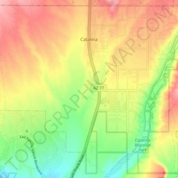
Name: Topografische Karte Catalina, Höhe, Relief.
Ort: Catalina, Pima County, Arizona, 85739, United States (32.45268 -110.93563 32.51170 -110.86173)
Durchschnittliche Höhe: 936 m
Minimale Höhe: 864 m
Maximale Höhe: 1’005 m
Andere topografische Karten
Klicken Sie auf eine Karte, um ihre Topografie, ihre Höhe und ihr Relief anzuzeigen.
Isolated
United States > Arizona > Pima County
Isolated, Pima County, Arizona, United States
Durchschnittliche Höhe: 1’052 m
Tucson
United States > Arizona > Pima County
Tucson, Pima County, Arizona, United States
Durchschnittliche Höhe: 821 m