Geolokalisieren

Topografische Karte Finedon

Klicken Sie auf die Karte, um die Höhe anzuzeigen.

Finedon

The town of Finedon rises to approximately 90 metres Above Ordinance Datum from the River Ise, with the historical centre of the settlement occupying a shallow south-west facing valley. The contemporary point of maximum elevation in the parish is the summit of the disused Sidegate Lane Landfill Site, located south of the town at approximately 108 metres Above Ordinance Datum. The parish covers a total area of 1,482 hectares (3,662 acres).

Wikipedia (CC-BY-SA 3.0)

Über diese Karte

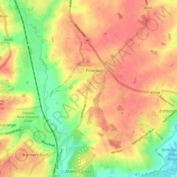
Name: Topografische Karte Finedon, Höhe, Relief.

Ort: Finedon, North Northamptonshire, England, United Kingdom (52.31263 -0.68627 52.36156 -0.62272)

Durchschnittliche Höhe: 75 m

Minimale Höhe: 34 m

Maximale Höhe: 100 m

Andere topografische Karten

Klicken Sie auf eine Karte, um ihre Topografie, ihre Höhe und ihr Relief anzuzeigen.

Corby

United Kingdom > England > North Northamptonshire

Durchschnittliche Höhe: 103 m

Duddington

United Kingdom > England > North Northamptonshire

Durchschnittliche Höhe: 67 m

Middleton

United Kingdom > England > North Northamptonshire

Durchschnittliche Höhe: 96 m

Gretton

United Kingdom > England > North Northamptonshire

Durchschnittliche Höhe: 81 m

Great Oakley

United Kingdom > England > North Northamptonshire > Corby

Durchschnittliche Höhe: 109 m

Lowick

United Kingdom > England > North Northamptonshire

Durchschnittliche Höhe: 57 m

Corby

United Kingdom > England > North Northamptonshire

Durchschnittliche Höhe: 103 m

Wellingborough

United Kingdom > England > North Northamptonshire

Durchschnittliche Höhe: 76 m

Laxton

United Kingdom > England > North Northamptonshire

Durchschnittliche Höhe: 86 m

East Carlton

United Kingdom > England > North Northamptonshire

Durchschnittliche Höhe: 101 m

Titchmarsh

United Kingdom > England > North Northamptonshire

Durchschnittliche Höhe: 45 m

Brigstock

United Kingdom > England > North Northamptonshire

Durchschnittliche Höhe: 79 m

Aldwincle

United Kingdom > England > North Northamptonshire

Durchschnittliche Höhe: 44 m

Dingley

United Kingdom > England > North Northamptonshire

Durchschnittliche Höhe: 110 m

Little Stanion

United Kingdom > England > North Northamptonshire

Durchschnittliche Höhe: 97 m

Wadenhoe

United Kingdom > England > North Northamptonshire

Durchschnittliche Höhe: 48 m

Pipewell

United Kingdom > England > North Northamptonshire

Durchschnittliche Höhe: 124 m

Cottingham

United Kingdom > England > North Northamptonshire

Durchschnittliche Höhe: 97 m

Rushton

United Kingdom > England > North Northamptonshire

Durchschnittliche Höhe: 112 m

Slade

United Kingdom > England > North Northamptonshire > Orton

Durchschnittliche Höhe: 123 m

Woodford

United Kingdom > England > North Northamptonshire > Woodford

Durchschnittliche Höhe: 55 m

Ringstead

United Kingdom > England > North Northamptonshire > Ringstead

Durchschnittliche Höhe: 53 m

Twywell

United Kingdom > England > North Northamptonshire

Durchschnittliche Höhe: 71 m

Glapthorn

United Kingdom > England > North Northamptonshire

Durchschnittliche Höhe: 49 m

Weekley

United Kingdom > England > North Northamptonshire

Durchschnittliche Höhe: 92 m

Hargrave

United Kingdom > England > North Northamptonshire

Durchschnittliche Höhe: 70 m

Braybrooke

United Kingdom > England > North Northamptonshire

Durchschnittliche Höhe: 123 m

Rüste dich für dein nächstes Abenteuer:

🔌Powerbanks für Outdoor - Robuste Akkus für GPS und Smartphone unterwegs
🔥Feuerstahl - Zuverlässiges Feuermachen bei jedem Wetter
🛶Wasserdichte Taschen - Schützt Ausrüstung bei Regen und Wasseraktivitäten
🌧️Rucksack-Regenhüllen - Hält die Ausrüstung auch bei Starkregen trocken
🔦Campinglaternen - Rundum-Beleuchtung für das Zelt

Als Amazon-Partner verdient diese Seite an qualifizierten Käufen, ohne dass Ihnen zusätzliche Kosten entstehen.