
Topografische Karte Santa María de la Alameda
Interaktive Karte
Klicken Sie auf die Karte, um die Höhe anzuzeigen.
Über diese Karte
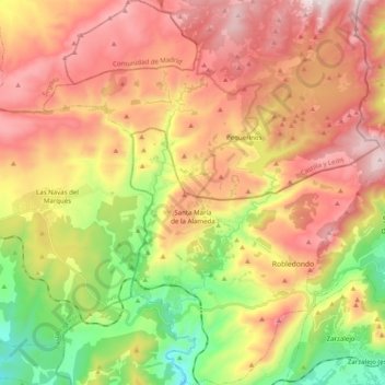
Name: Topografische Karte Santa María de la Alameda, Höhe, Relief.
Durchschnittliche Höhe: 1’339 m
Minimale Höhe: 872 m
Maximale Höhe: 1’783 m
Originally a group of cattle-raising hamlets, the municipality comprises different settlements: Las Herreras, El Pimpollar, La Hoya, Navalespino, La Paradilla, Robledondo, Santa María de la Alameda and Santa María Estación. In time, the nucleus of "Santa María Estación", developed around the railway station, has grown to become the most populated settlement. The capital of the municipality (the namesake "Santa María de la Alameda") is located at an elevation of 1,409 metres. The municipality covers an area of 74.41 km2, including the exclave of Dehesa de la Cepeda, a mostly pasture area geographically located between the provinces of Ávila and Segovia in the autonomous community of Castile and León.
Andere topografische Karten
Klicken Sie auf eine Karte, um ihre Topografie, ihre Höhe und ihr Relief anzuzeigen.
Navalagamella
Spain > Community of Madrid > Sierra Oeste
Navalagamella, Sierra Oeste, Community of Madrid, 28212, Spain
Durchschnittliche Höhe: 718 m