
Spenden
Rüste dich für dein nächstes Abenteuer:
Als Amazon-Partner verdient diese Seite an qualifizierten Käufen, ohne dass Ihnen zusätzliche Kosten entstehen.
Topografische Karte North Franklin
Klicken Sie auf die Karte, um die Höhe anzuzeigen.
Spenden
Rüste dich für dein nächstes Abenteuer:
Als Amazon-Partner verdient diese Seite an qualifizierten Käufen, ohne dass Ihnen zusätzliche Kosten entstehen.
Über diese Karte
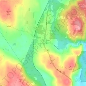
Name: Topografische Karte North Franklin, Höhe, Relief.
Durchschnittliche Höhe: 103 m
Minimale Höhe: 46 m
Maximale Höhe: 161 m
Spenden
Rüste dich für dein nächstes Abenteuer:
Als Amazon-Partner verdient diese Seite an qualifizierten Käufen, ohne dass Ihnen zusätzliche Kosten entstehen.
Andere topografische Karten
Klicken Sie auf eine Karte, um ihre Topografie, ihre Höhe und ihr Relief anzuzeigen.
Franklin
United States > Connecticut > Southeastern Connecticut Planning Region
Durchschnittliche Höhe: 95 m
Mystic
United States > Connecticut > Southeastern Connecticut Planning Region > Stonington > Mystic
Durchschnittliche Höhe: 15 m
Waterford
United States > Connecticut > Southeastern Connecticut Planning Region
Durchschnittliche Höhe: 30 m
Groton
United States > Connecticut > Southeastern Connecticut Planning Region
Durchschnittliche Höhe: 21 m
Spenden
Rüste dich für dein nächstes Abenteuer:
Als Amazon-Partner verdient diese Seite an qualifizierten Käufen, ohne dass Ihnen zusätzliche Kosten entstehen.
East Lyme
United States > Connecticut > Southeastern Connecticut Planning Region
The topography of East Lyme consists of rolling hills and lush valleys rounded by glaciers during the last Ice Age. Hills rise to elevations of 250 to 350 feet (76 to 107 m) above sea level in the eastern and central areas of the town. The highest point in town is an unnamed hill with an elevation of 500 feet…
Durchschnittliche Höhe: 41 m
Bozrah
United States > Connecticut > Southeastern Connecticut Planning Region
Durchschnittliche Höhe: 97 m
Salem
United States > Connecticut > Southeastern Connecticut Planning Region
Durchschnittliche Höhe: 119 m
Ledyard
United States > Connecticut > Southeastern Connecticut Planning Region
Durchschnittliche Höhe: 53 m
Spenden
Rüste dich für dein nächstes Abenteuer:
Als Amazon-Partner verdient diese Seite an qualifizierten Käufen, ohne dass Ihnen zusätzliche Kosten entstehen.
Noank
United States > Connecticut > Southeastern Connecticut Planning Region > Groton > Noank
Durchschnittliche Höhe: 15 m
Stonington
United States > Connecticut > Southeastern Connecticut Planning Region
Durchschnittliche Höhe: 25 m
Gales Ferry
United States > Connecticut > Southeastern Connecticut Planning Region > Ledyard > Gales Ferry
Durchschnittliche Höhe: 24 m
Colchester
United States > Connecticut > Southeastern Connecticut Planning Region
Durchschnittliche Höhe: 134 m
Spenden
Rüste dich für dein nächstes Abenteuer:
Als Amazon-Partner verdient diese Seite an qualifizierten Käufen, ohne dass Ihnen zusätzliche Kosten entstehen.
Norwich
United States > Connecticut > Southeastern Connecticut Planning Region
Durchschnittliche Höhe: 63 m
New London
United States > Connecticut > Southeastern Connecticut Planning Region
Durchschnittliche Höhe: 17 m
Lebanon
United States > Connecticut > Southeastern Connecticut Planning Region
Durchschnittliche Höhe: 119 m
Taftville
United States > Connecticut > Southeastern Connecticut Planning Region > Norwich
Durchschnittliche Höhe: 47 m
Spenden
Rüste dich für dein nächstes Abenteuer:
Als Amazon-Partner verdient diese Seite an qualifizierten Käufen, ohne dass Ihnen zusätzliche Kosten entstehen.
Austrailia Beach
United States > Connecticut > Southeastern Connecticut Planning Region > Mystic
Durchschnittliche Höhe: 19 m
Old Mystic
United States > Connecticut > Southeastern Connecticut Planning Region > Groton > Old Mystic
Durchschnittliche Höhe: 42 m
Windham
United States > Connecticut > Southeastern Connecticut Planning Region
Durchschnittliche Höhe: 103 m
North Stonington
United States > Connecticut > Southeastern Connecticut Planning Region
Durchschnittliche Höhe: 78 m
Spenden
Rüste dich für dein nächstes Abenteuer:
Als Amazon-Partner verdient diese Seite an qualifizierten Käufen, ohne dass Ihnen zusätzliche Kosten entstehen.
Mystic
United States > Connecticut > Southeastern Connecticut Planning Region > Stonington > Mystic
Durchschnittliche Höhe: 15 m
East Lyme
United States > Connecticut > Southeastern Connecticut Planning Region
The topography of East Lyme consists of rolling hills and lush valleys rounded by glaciers during the last Ice Age. Hills rise to elevations of 250 to 350 feet (76 to 107 m) above sea level in the eastern and central areas of the town. The highest point in town is an unnamed hill with an elevation of 500 feet…
Durchschnittliche Höhe: 41 m
New London
United States > Connecticut > Southeastern Connecticut Planning Region
Durchschnittliche Höhe: 17 m
Thames River
United States > Connecticut > Southeastern Connecticut Planning Region > Ledyard
Durchschnittliche Höhe: 52 m
Spenden
Rüste dich für dein nächstes Abenteuer:
Als Amazon-Partner verdient diese Seite an qualifizierten Käufen, ohne dass Ihnen zusätzliche Kosten entstehen.
Lebanon
United States > Connecticut > Southeastern Connecticut Planning Region
Durchschnittliche Höhe: 119 m
Austrailia Beach
United States > Connecticut > Southeastern Connecticut Planning Region > Mystic
Durchschnittliche Höhe: 19 m
Franklin
United States > Connecticut > Southeastern Connecticut Planning Region
Durchschnittliche Höhe: 95 m
Windham
United States > Connecticut > Southeastern Connecticut Planning Region
Durchschnittliche Höhe: 103 m
Spenden
Rüste dich für dein nächstes Abenteuer:
Als Amazon-Partner verdient diese Seite an qualifizierten Käufen, ohne dass Ihnen zusätzliche Kosten entstehen.
Ledyard
United States > Connecticut > Southeastern Connecticut Planning Region
Durchschnittliche Höhe: 53 m
Montville
United States > Connecticut > Southeastern Connecticut Planning Region
Durchschnittliche Höhe: 80 m
Taftville Reservoir #1 Dam
United States > Connecticut > Southeastern Connecticut Planning Region > Norwich
Durchschnittliche Höhe: 75 m
Montville
United States > Connecticut > Southeastern Connecticut Planning Region
Durchschnittliche Höhe: 76 m
Spenden
Rüste dich für dein nächstes Abenteuer:
Als Amazon-Partner verdient diese Seite an qualifizierten Käufen, ohne dass Ihnen zusätzliche Kosten entstehen.
Sprague
United States > Connecticut > Southeastern Connecticut Planning Region
Durchschnittliche Höhe: 79 m
Blue Lake
United States > Connecticut > Southeastern Connecticut Planning Region > North Stonington
Durchschnittliche Höhe: 106 m
Thames River
United States > Connecticut > Southeastern Connecticut Planning Region > Waterford
Durchschnittliche Höhe: 52 m
New London
United States > Connecticut > Southeastern Connecticut Planning Region
Durchschnittliche Höhe: 17 m
Spenden
Rüste dich für dein nächstes Abenteuer:
Als Amazon-Partner verdient diese Seite an qualifizierten Käufen, ohne dass Ihnen zusätzliche Kosten entstehen.
Salem
United States > Connecticut > Southeastern Connecticut Planning Region
Durchschnittliche Höhe: 119 m
Austrailia Beach
United States > Connecticut > Southeastern Connecticut Planning Region > Mystic
Durchschnittliche Höhe: 19 m
Stonington
United States > Connecticut > Southeastern Connecticut Planning Region
Durchschnittliche Höhe: 25 m
Bozrah
United States > Connecticut > Southeastern Connecticut Planning Region
Durchschnittliche Höhe: 97 m
Spenden
Rüste dich für dein nächstes Abenteuer:
Als Amazon-Partner verdient diese Seite an qualifizierten Käufen, ohne dass Ihnen zusätzliche Kosten entstehen.
Norwich
United States > Connecticut > Southeastern Connecticut Planning Region
Durchschnittliche Höhe: 63 m
Austrailia Beach
United States > Connecticut > Southeastern Connecticut Planning Region > Mystic
Durchschnittliche Höhe: 19 m
Hanover Reservoir
United States > Connecticut > Southeastern Connecticut Planning Region > Hanover
Durchschnittliche Höhe: 91 m
Preston
United States > Connecticut > Southeastern Connecticut Planning Region
Durchschnittliche Höhe: 66 m
Spenden
Rüste dich für dein nächstes Abenteuer:
Als Amazon-Partner verdient diese Seite an qualifizierten Käufen, ohne dass Ihnen zusätzliche Kosten entstehen.
Willimantic
United States > Connecticut > Southeastern Connecticut Planning Region > Willimantic > Windham
Durchschnittliche Höhe: 95 m
Groton
United States > Connecticut > Southeastern Connecticut Planning Region
Durchschnittliche Höhe: 19 m
North Stonington
United States > Connecticut > Southeastern Connecticut Planning Region
Durchschnittliche Höhe: 73 m
Lisbon
United States > Connecticut > Southeastern Connecticut Planning Region
Durchschnittliche Höhe: 64 m
Spenden
Rüste dich für dein nächstes Abenteuer:
Als Amazon-Partner verdient diese Seite an qualifizierten Käufen, ohne dass Ihnen zusätzliche Kosten entstehen.
Norwich
United States > Connecticut > Southeastern Connecticut Planning Region
Durchschnittliche Höhe: 63 m
Waterford
United States > Connecticut > Southeastern Connecticut Planning Region
Durchschnittliche Höhe: 30 m
Harkness Memorial State Park
United States > Connecticut > Southeastern Connecticut Planning Region > Waterford
Durchschnittliche Höhe: 12 m
Stonington
United States > Connecticut > Southeastern Connecticut Planning Region
Durchschnittliche Höhe: 25 m
Spenden
Rüste dich für dein nächstes Abenteuer:
Als Amazon-Partner verdient diese Seite an qualifizierten Käufen, ohne dass Ihnen zusätzliche Kosten entstehen.
Groton
United States > Connecticut > Southeastern Connecticut Planning Region
Durchschnittliche Höhe: 21 m