
Topografische Karte Jonesville
Interaktive Karte
Klicken Sie auf die Karte, um die Höhe anzuzeigen.
Über diese Karte
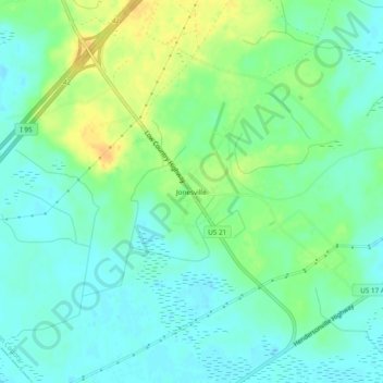
Name: Topografische Karte Jonesville, Höhe, Relief.
Ort: Jonesville, Colleton County, South Carolina, United States (32.71629 -80.83594 32.75629 -80.79594)
Durchschnittliche Höhe: 11 m
Minimale Höhe: 0 m
Maximale Höhe: 28 m
Andere topografische Karten
Klicken Sie auf eine Karte, um ihre Topografie, ihre Höhe und ihr Relief anzuzeigen.
Islandton
United States > South Carolina > Colleton County
Islandton, Colleton County, South Carolina, 29929, United States
Durchschnittliche Höhe: 21 m
Red Oak Corner
United States > South Carolina > Colleton County
Red Oak Corner, Colleton County, South Carolina, 29435, United States
Durchschnittliche Höhe: 13 m
Round O
United States > South Carolina > Colleton County
Round O, Colleton County, South Carolina, 29474, United States
Durchschnittliche Höhe: 11 m
Edisto Beach
United States > South Carolina > Colleton County > Edisto Beach
Edisto Beach, Colleton County, South Carolina, United States
Durchschnittliche Höhe: 3 m